

Delhi’s Border Gambit in Manipur: Unravelling Colonial Cartography and Emerging Borderland Governance

India’s laws do not provide a uniform definition of border areas. The concept of border area is a fluid one, depending on the particular legal provisions. There are certain advantages to ambiguity as the Indian administration can adjust the borders as it sees fit. The Border Security Force (BSF) Act, 1968 allows the central government […]

The post Delhi’s Border Gambit in Manipur: Unravelling Colonial Cartography and Emerging Borderland Governance first appeared on The Frontier Manipur.

India’s laws do not provide a uniform definition of border areas. The concept of border area is a fluid one, depending on the particular legal provisions. There are certain advantages to ambiguity as the Indian administration can adjust the borders as it sees fit. The Border Security Force (BSF) Act, 1968 allows the central government to notify the areas within Manipur where the BSF has police powers. For most of the western states (Punjab, Gujarat, Rajasthan), the jurisdiction extends to 50 km from the border, but for Manipur, the entire state falls under the BSF’s jurisdiction.

By Dhiren A. Sadokpam

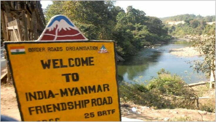
In the summer of 2026, as New Delhi seems to speed up its Rs 31,000-crore project to fence the 1,643-kilometre India-Myanmar frontier, a far more consequential subtext has emerged. There were also reports that the Government of India is reportedly examining a proposal to exchange approximately 1.4 square miles of territory near Manipur’s Chandel district—between border pillars 65 and 68—to expedite demarcation. The Ministry of External Affairs admits that “discussions are continuing on some unsettled sectors.”

While the government rushes to fence the border, the people in Manipur are worrying about their territorial integrity. Coordinating Committee on Manipur Integrity (COCOMI) had warned the Government of India against any move to transfer the territory of Manipur to Myanmar threatening mass agitation if the Centre attempts to do so.  COCOMI also expressed unhappiness over a MEA advisory dated 26 May, which gives a three-month time frame for demarcating the border, but makes no mention of any territorial gain for India. The organisation termed Manipur’s territorial integrity as “a red line” and said any move to shrink its boundaries would be opposed by the people of Manipur. Noting that there are stretches of disputed borders in Manipur, COCOMI said the situation is “particularly grave” in certain areas, such as BPs 64 and 68 at Molcham, 75 and 79 at Moreh and 88 and 95 at Choro Khunou. “The question also arises if India-Myanmar border talks and laying of auxiliary pillars in the Molcham sector are being done at the expense of Manipur’s territory,” COCOMI added.

For the ethnic communities whose ancestral lands straddle this frontier, the ambiguity is not diplomatic—it is existential. United Naga Council (UNC) in Manipur took the matter one step further by petitioning to the United Nations Permanent Forum on Indigenous Issues, demanding that they stop the so-called plan to give up indigenous ancestral territory and for the UN to intervene to enforce Free, Prior, and Informed Consent (FPIC).

However, it must be understood that the Indian administration has the legal leeway to redraw international boundaries without the consent of local communities due to the lack of a uniform definition of “border areas” and ambiguous legal mandates.

The Fence, the Exchange, the Unclear Demarcation

The Indian government has every reason to fence the border with Myanmar. Illegal immigration, weapon and drug trafficking, and the movement of insurgent groups and their weapons across the border prompted the Home Minister, Amit Shah, to state that this move would address “the root cause of the problem.” At the same time, it has become apparent that some of the border areas between India and Myanmar remain unsettled. The two countries signed the agreement on the border in 1967, but there are still “some unsettled sectors” along pillars 64-68 at Molcham, 75-79 at Moreh, and 88-95 at Choro Khunou. The government is considering exchanging territory to complete the demarcation in the sector of pillars 65-68 within a specified period.

The history of India’s borders with China and Myanmar shows that they were drawn based on an imperial framework. The border with Myanmar was defined in the Treaty of Yandaboo in 1826, which officially transferred Assam and Manipur to British rule. Later, in 1937, Burma was separated from India, dividing communities that had previously lived within the same administrative boundaries. The situation with China is similar, albeit more complicated, with the McMahon Line being another colonial inheritance. McMahon Line was initially opposed by the British government but was “reasserted in 1935 when Burma was separated from the Indian Empire.” The parallels between the India-China and India-Myanmar borders end with colonial roots. Each of them was imposed from outside, had ambiguous validity, and was applied unevenly.

The Legal Quick Sand of “Border Area”

India’s laws do not provide a uniform definition of border areas. In fact, the concept of border area is a fluid one, depending on the particular legal provisions. There are certain advantages to ambiguity as the Indian administration can adjust the borders as it sees fit. For example, the Border Security Force (BSF) Act, 1968 allows the central government to notify the areas within Manipur where the BSF has police powers. For most of the western states (Punjab, Gujarat, Rajasthan), the jurisdiction extends to 50 km from the border, but for Manipur, the entire state falls under the BSF’s jurisdiction. Since the BSF Act does not mention a “border belt” for Manipur, the Union Home Ministry has the power to take any action it considers necessary. Thus, if New Delhi decides to exchange the 1.4 square miles near the pillars 65-68, the BSF’s jurisdiction over Manipur will extend to the new border.

The lack of a uniform definition of a border area affects Manipur’s development in a more direct way. The Border Area Development Programme (BADP) is the only other national policy that mentions distance – 50 km from the border – in relation to Manipur. Within the first 10 km, developmental grants are provided for border villages under the BADP. The areas which will lose the land near the pillars 65-68 (Choro Khunou), or 75-79 (Moreh), and 88-95 (Choro Khunou) will no longer be eligible for developmental grants. There is no language in the BSF Act that obliges the Union government to consult Manipur’s legislative assembly or the local villagers before changing the border. Therefore, New Delhi can change the line between the international boundary and Manipur’s territory, adjusting the BADP coverage, without mentioning it anywhere. Manipur will bear the burden of the responsibility for increased security, while the benefits of development policy will be limited to a narrow strip within the first 10 km.

The Other Side of the Coin: Passport Act, ILP, and Frontier Exclusion

The Inner Line Permit (ILP) system dates back to the era of British rule in India. The rules were introduced in 1873 under the Bengal Eastern Frontier Regulation Act and were designed to protect British trade interests in Manipur. The Passport (Entry into India) Act, 1920, controls and regulates the entry of foreign citizens into India but does not specify where the “frontier” exactly extends. By introducing the ILP for the entire state of Manipur (notification issued in 2019) in addition to the BSF Act, New Delhi creates a border regime that excludes Manipur from the administrative and territorial integrity of India. First, the ILP permits foreigners to stay in Manipur, while Indians – even from neighboring states – need a permit. Second, the BSF Act restricts the movement of Myanmar nationals. However, neither the Passport Act nor the ILP system refers to the “frontier,” except for excluding foreigners from visiting Manipur. Thus, the residents of Manipur are trapped between the two laws that regulate the entry and exit of foreigners but do not consider the residents of Manipur, particularly those living within the first 50 km from the border, as citizens of the mainland.

The residents of Manipur are caught between the rules that prohibit them from visiting “foreign lands” and the rules that prevent “foreigners” from entering Manipur or even travelling within the state. At the same time, the government has the opportunity to “adjust the border” to tighten or loosen the rules for foreigners. The colonial framework, which separates Manipur from the rest of India, is also designed in such a way that the government can exclude certain areas and people from the general legal jurisdiction. This explains why the ILP system regulates entry into Manipur but does not prohibit Manipuris from exiting the state. New Delhi can “tighten the screws” by imposing stricter restrictions on the movement of Manipur citizens into neighbouring states, while “loosening the border” for other ethnic groups.

The Human Cost: Loss of Land, Loss of Kinship and Political Memory

The border between India and Myanmar is a “divide” that threatens to split communities that have lived together for generations. According to the Free Movement Regime (FMR), the residents of Manipur within the 40 km border belt could travel freely between the two countries without any documents. The FMR is being gradually withdrawn as the government tries to enforce stricter restrictions: the free movement now extends to 10 km, and the Indian administration plans to “notify the withdrawal of FMR altogether.”

Fencing the border and controlling the movement of people will lead to “loss of agricultural land, grazing land, paddy fields, rivers, sand resources and traditional hunting grounds.” Local villagers reported that India “had shifted a boundary pillar within their territory by about three km.”

The communities are already suffering from the consequences of the border, and the situation may deteriorate after years of tension between India and Myanmar. Since the military coup in Myanmar, more than 50,000 people have taken refuge in Mizoram and Manipur. The Indian government has little choice but to stop the influx of refugees, but the construction of the fence, as well as the withdrawal of the FMR, will cause irreparable damage.

The New Regime: Securitisation and Biometric Control

New Delhi is eager to impose a biometric security policy on the border. The draft Immigration and Foreigners Act, 2025 states that the new Act is intended to create a “new paradigm of border management” and replace “obsolescent laws.” New Delhi has developed a plan to create a “360-degree security environment for all border districts.” Recently, the authorities have taken steps to remove unauthorised structures within the 0-15 km belt. However, the very idea of ??the “new border regime” is doubtful since India’s laws on the management of border areas are based on colonial principles. The Passport Act 1920, which regulates travel to and from Manipur, was also enacted during the British Raj. The current laws on border security (BSF Act) were enacted in response to specific crises.

While the Indian government announced the dawn of a new era in border management, it is unclear how the new rules will affect the lives of border residents. There is no law specifically devoted to border demarcation and consultative procedures with local communities. At the same time, India’s Union government already faces disputes with some of the Northeastern states over jurisdiction.

The Legacy of the Partition Era

The proposed modification of the border between India and Myanmar poses considerable political risk for both countries. Manipur has suffered significantly from ethnic violence in recent years, and the government may find itself under pressure to revise the contested boundary. From India’s perspective, adopting this measure would make it possible to finalise the border, thereby completing the fencing project, shortening the border line, and reducing the opportunities for illegal crossings of armed groups. Additionally, improved relations with Myanmar will allow India to develop transport infrastructure and jointly combat armed insurgencies. However, it is essential to acknowledge that the imposition of borders without local community consent does not increase their security but may lead to other unforeseeable challenges.

(Dhiren A. Sadokpam is Editor-in-Chief, The Frontier Manipur)


The post Delhi’s Border Gambit in Manipur: Unravelling Colonial Cartography and Emerging Borderland Governance first appeared on The Frontier Manipur.

Read more / Original news source: https://thefrontiermanipur.com/delhis-border-gambit-in-manipur-unravelling-colonial-cartography-and-emerging-borderland-governance/

Delhi’s Border Gambit in Manipur: Unravelling Colonial Cartography and Emerging Borderland Governance

India’s laws do not provide a uniform definition of border areas. The concept of border area is a fluid one, depending on the particular legal provisions. There are certain advantages to ambiguity as the Indian administration can adjust the borders as it sees fit. The Border Security Force (BSF) Act, 1968 allows the central government […]

The post Delhi’s Border Gambit in Manipur: Unravelling Colonial Cartography and Emerging Borderland Governance first appeared on The Frontier Manipur.

India’s laws do not provide a uniform definition of border areas. The concept of border area is a fluid one, depending on the particular legal provisions. There are certain advantages to ambiguity as the Indian administration can adjust the borders as it sees fit. The Border Security Force (BSF) Act, 1968 allows the central government to notify the areas within Manipur where the BSF has police powers. For most of the western states (Punjab, Gujarat, Rajasthan), the jurisdiction extends to 50 km from the border, but for Manipur, the entire state falls under the BSF’s jurisdiction.

By Dhiren A. Sadokpam

In the summer of 2026, as New Delhi seems to speed up its Rs 31,000-crore project to fence the 1,643-kilometre India-Myanmar frontier, a far more consequential subtext has emerged. There were also reports that the Government of India is reportedly examining a proposal to exchange approximately 1.4 square miles of territory near Manipur’s Chandel district—between border pillars 65 and 68—to expedite demarcation. The Ministry of External Affairs admits that “discussions are continuing on some unsettled sectors.”

While the government rushes to fence the border, the people in Manipur are worrying about their territorial integrity. Coordinating Committee on Manipur Integrity (COCOMI) had warned the Government of India against any move to transfer the territory of Manipur to Myanmar threatening mass agitation if the Centre attempts to do so.  COCOMI also expressed unhappiness over a MEA advisory dated 26 May, which gives a three-month time frame for demarcating the border, but makes no mention of any territorial gain for India. The organisation termed Manipur’s territorial integrity as “a red line” and said any move to shrink its boundaries would be opposed by the people of Manipur. Noting that there are stretches of disputed borders in Manipur, COCOMI said the situation is “particularly grave” in certain areas, such as BPs 64 and 68 at Molcham, 75 and 79 at Moreh and 88 and 95 at Choro Khunou. “The question also arises if India-Myanmar border talks and laying of auxiliary pillars in the Molcham sector are being done at the expense of Manipur’s territory,” COCOMI added.

For the ethnic communities whose ancestral lands straddle this frontier, the ambiguity is not diplomatic—it is existential. United Naga Council (UNC) in Manipur took the matter one step further by petitioning to the United Nations Permanent Forum on Indigenous Issues, demanding that they stop the so-called plan to give up indigenous ancestral territory and for the UN to intervene to enforce Free, Prior, and Informed Consent (FPIC).

However, it must be understood that the Indian administration has the legal leeway to redraw international boundaries without the consent of local communities due to the lack of a uniform definition of “border areas” and ambiguous legal mandates.

The Fence, the Exchange, the Unclear Demarcation

The Indian government has every reason to fence the border with Myanmar. Illegal immigration, weapon and drug trafficking, and the movement of insurgent groups and their weapons across the border prompted the Home Minister, Amit Shah, to state that this move would address “the root cause of the problem.” At the same time, it has become apparent that some of the border areas between India and Myanmar remain unsettled. The two countries signed the agreement on the border in 1967, but there are still “some unsettled sectors” along pillars 64-68 at Molcham, 75-79 at Moreh, and 88-95 at Choro Khunou. The government is considering exchanging territory to complete the demarcation in the sector of pillars 65-68 within a specified period.

The history of India’s borders with China and Myanmar shows that they were drawn based on an imperial framework. The border with Myanmar was defined in the Treaty of Yandaboo in 1826, which officially transferred Assam and Manipur to British rule. Later, in 1937, Burma was separated from India, dividing communities that had previously lived within the same administrative boundaries. The situation with China is similar, albeit more complicated, with the McMahon Line being another colonial inheritance. McMahon Line was initially opposed by the British government but was “reasserted in 1935 when Burma was separated from the Indian Empire.” The parallels between the India-China and India-Myanmar borders end with colonial roots. Each of them was imposed from outside, had ambiguous validity, and was applied unevenly.

The Legal Quick Sand of “Border Area”

India’s laws do not provide a uniform definition of border areas. In fact, the concept of border area is a fluid one, depending on the particular legal provisions. There are certain advantages to ambiguity as the Indian administration can adjust the borders as it sees fit. For example, the Border Security Force (BSF) Act, 1968 allows the central government to notify the areas within Manipur where the BSF has police powers. For most of the western states (Punjab, Gujarat, Rajasthan), the jurisdiction extends to 50 km from the border, but for Manipur, the entire state falls under the BSF’s jurisdiction. Since the BSF Act does not mention a “border belt” for Manipur, the Union Home Ministry has the power to take any action it considers necessary. Thus, if New Delhi decides to exchange the 1.4 square miles near the pillars 65-68, the BSF’s jurisdiction over Manipur will extend to the new border.

The lack of a uniform definition of a border area affects Manipur’s development in a more direct way. The Border Area Development Programme (BADP) is the only other national policy that mentions distance – 50 km from the border – in relation to Manipur. Within the first 10 km, developmental grants are provided for border villages under the BADP. The areas which will lose the land near the pillars 65-68 (Choro Khunou), or 75-79 (Moreh), and 88-95 (Choro Khunou) will no longer be eligible for developmental grants. There is no language in the BSF Act that obliges the Union government to consult Manipur’s legislative assembly or the local villagers before changing the border. Therefore, New Delhi can change the line between the international boundary and Manipur’s territory, adjusting the BADP coverage, without mentioning it anywhere. Manipur will bear the burden of the responsibility for increased security, while the benefits of development policy will be limited to a narrow strip within the first 10 km.

The Other Side of the Coin: Passport Act, ILP, and Frontier Exclusion

The Inner Line Permit (ILP) system dates back to the era of British rule in India. The rules were introduced in 1873 under the Bengal Eastern Frontier Regulation Act and were designed to protect British trade interests in Manipur. The Passport (Entry into India) Act, 1920, controls and regulates the entry of foreign citizens into India but does not specify where the “frontier” exactly extends. By introducing the ILP for the entire state of Manipur (notification issued in 2019) in addition to the BSF Act, New Delhi creates a border regime that excludes Manipur from the administrative and territorial integrity of India. First, the ILP permits foreigners to stay in Manipur, while Indians – even from neighboring states – need a permit. Second, the BSF Act restricts the movement of Myanmar nationals. However, neither the Passport Act nor the ILP system refers to the “frontier,” except for excluding foreigners from visiting Manipur. Thus, the residents of Manipur are trapped between the two laws that regulate the entry and exit of foreigners but do not consider the residents of Manipur, particularly those living within the first 50 km from the border, as citizens of the mainland.

The residents of Manipur are caught between the rules that prohibit them from visiting “foreign lands” and the rules that prevent “foreigners” from entering Manipur or even travelling within the state. At the same time, the government has the opportunity to “adjust the border” to tighten or loosen the rules for foreigners. The colonial framework, which separates Manipur from the rest of India, is also designed in such a way that the government can exclude certain areas and people from the general legal jurisdiction. This explains why the ILP system regulates entry into Manipur but does not prohibit Manipuris from exiting the state. New Delhi can “tighten the screws” by imposing stricter restrictions on the movement of Manipur citizens into neighbouring states, while “loosening the border” for other ethnic groups.

The Human Cost: Loss of Land, Loss of Kinship and Political Memory

The border between India and Myanmar is a “divide” that threatens to split communities that have lived together for generations. According to the Free Movement Regime (FMR), the residents of Manipur within the 40 km border belt could travel freely between the two countries without any documents. The FMR is being gradually withdrawn as the government tries to enforce stricter restrictions: the free movement now extends to 10 km, and the Indian administration plans to “notify the withdrawal of FMR altogether.”

Fencing the border and controlling the movement of people will lead to “loss of agricultural land, grazing land, paddy fields, rivers, sand resources and traditional hunting grounds.” Local villagers reported that India “had shifted a boundary pillar within their territory by about three km.”

The communities are already suffering from the consequences of the border, and the situation may deteriorate after years of tension between India and Myanmar. Since the military coup in Myanmar, more than 50,000 people have taken refuge in Mizoram and Manipur. The Indian government has little choice but to stop the influx of refugees, but the construction of the fence, as well as the withdrawal of the FMR, will cause irreparable damage.

The New Regime: Securitisation and Biometric Control

New Delhi is eager to impose a biometric security policy on the border. The draft Immigration and Foreigners Act, 2025 states that the new Act is intended to create a “new paradigm of border management” and replace “obsolescent laws.” New Delhi has developed a plan to create a “360-degree security environment for all border districts.” Recently, the authorities have taken steps to remove unauthorised structures within the 0-15 km belt. However, the very idea of ??the “new border regime” is doubtful since India’s laws on the management of border areas are based on colonial principles. The Passport Act 1920, which regulates travel to and from Manipur, was also enacted during the British Raj. The current laws on border security (BSF Act) were enacted in response to specific crises.

While the Indian government announced the dawn of a new era in border management, it is unclear how the new rules will affect the lives of border residents. There is no law specifically devoted to border demarcation and consultative procedures with local communities. At the same time, India’s Union government already faces disputes with some of the Northeastern states over jurisdiction.

The Legacy of the Partition Era

The proposed modification of the border between India and Myanmar poses considerable political risk for both countries. Manipur has suffered significantly from ethnic violence in recent years, and the government may find itself under pressure to revise the contested boundary. From India’s perspective, adopting this measure would make it possible to finalise the border, thereby completing the fencing project, shortening the border line, and reducing the opportunities for illegal crossings of armed groups. Additionally, improved relations with Myanmar will allow India to develop transport infrastructure and jointly combat armed insurgencies. However, it is essential to acknowledge that the imposition of borders without local community consent does not increase their security but may lead to other unforeseeable challenges.

(Dhiren A. Sadokpam is Editor-in-Chief, The Frontier Manipur)


The post Delhi’s Border Gambit in Manipur: Unravelling Colonial Cartography and Emerging Borderland Governance first appeared on The Frontier Manipur.

Read more / Original news source: https://thefrontiermanipur.com/delhis-border-gambit-in-manipur-unravelling-colonial-cartography-and-emerging-borderland-governance/

Delhi’s Border Gambit in Manipur: Unravelling Colonial Cartography and Emerging Borderland Governance

India’s laws do not provide a uniform definition of border areas. The concept of border area is a fluid one, depending on the particular legal provisions. There are certain advantages to ambiguity as the Indian administration can adjust the borders as it sees fit. The Border Security Force (BSF) Act, 1968 allows the central government […]

The post Delhi’s Border Gambit in Manipur: Unravelling Colonial Cartography and Emerging Borderland Governance first appeared on The Frontier Manipur.

India’s laws do not provide a uniform definition of border areas. The concept of border area is a fluid one, depending on the particular legal provisions. There are certain advantages to ambiguity as the Indian administration can adjust the borders as it sees fit. The Border Security Force (BSF) Act, 1968 allows the central government to notify the areas within Manipur where the BSF has police powers. For most of the western states (Punjab, Gujarat, Rajasthan), the jurisdiction extends to 50 km from the border, but for Manipur, the entire state falls under the BSF’s jurisdiction.

By Dhiren A. Sadokpam

In the summer of 2026, as New Delhi seems to speed up its Rs 31,000-crore project to fence the 1,643-kilometre India-Myanmar frontier, a far more consequential subtext has emerged. There were also reports that the Government of India is reportedly examining a proposal to exchange approximately 1.4 square miles of territory near Manipur’s Chandel district—between border pillars 65 and 68—to expedite demarcation. The Ministry of External Affairs admits that “discussions are continuing on some unsettled sectors.”

While the government rushes to fence the border, the people in Manipur are worrying about their territorial integrity. Coordinating Committee on Manipur Integrity (COCOMI) had warned the Government of India against any move to transfer the territory of Manipur to Myanmar threatening mass agitation if the Centre attempts to do so.  COCOMI also expressed unhappiness over a MEA advisory dated 26 May, which gives a three-month time frame for demarcating the border, but makes no mention of any territorial gain for India. The organisation termed Manipur’s territorial integrity as “a red line” and said any move to shrink its boundaries would be opposed by the people of Manipur. Noting that there are stretches of disputed borders in Manipur, COCOMI said the situation is “particularly grave” in certain areas, such as BPs 64 and 68 at Molcham, 75 and 79 at Moreh and 88 and 95 at Choro Khunou. “The question also arises if India-Myanmar border talks and laying of auxiliary pillars in the Molcham sector are being done at the expense of Manipur’s territory,” COCOMI added.

For the ethnic communities whose ancestral lands straddle this frontier, the ambiguity is not diplomatic—it is existential. United Naga Council (UNC) in Manipur took the matter one step further by petitioning to the United Nations Permanent Forum on Indigenous Issues, demanding that they stop the so-called plan to give up indigenous ancestral territory and for the UN to intervene to enforce Free, Prior, and Informed Consent (FPIC).

However, it must be understood that the Indian administration has the legal leeway to redraw international boundaries without the consent of local communities due to the lack of a uniform definition of “border areas” and ambiguous legal mandates.

The Fence, the Exchange, the Unclear Demarcation

The Indian government has every reason to fence the border with Myanmar. Illegal immigration, weapon and drug trafficking, and the movement of insurgent groups and their weapons across the border prompted the Home Minister, Amit Shah, to state that this move would address “the root cause of the problem.” At the same time, it has become apparent that some of the border areas between India and Myanmar remain unsettled. The two countries signed the agreement on the border in 1967, but there are still “some unsettled sectors” along pillars 64-68 at Molcham, 75-79 at Moreh, and 88-95 at Choro Khunou. The government is considering exchanging territory to complete the demarcation in the sector of pillars 65-68 within a specified period.

The history of India’s borders with China and Myanmar shows that they were drawn based on an imperial framework. The border with Myanmar was defined in the Treaty of Yandaboo in 1826, which officially transferred Assam and Manipur to British rule. Later, in 1937, Burma was separated from India, dividing communities that had previously lived within the same administrative boundaries. The situation with China is similar, albeit more complicated, with the McMahon Line being another colonial inheritance. McMahon Line was initially opposed by the British government but was “reasserted in 1935 when Burma was separated from the Indian Empire.” The parallels between the India-China and India-Myanmar borders end with colonial roots. Each of them was imposed from outside, had ambiguous validity, and was applied unevenly.

The Legal Quick Sand of “Border Area”

India’s laws do not provide a uniform definition of border areas. In fact, the concept of border area is a fluid one, depending on the particular legal provisions. There are certain advantages to ambiguity as the Indian administration can adjust the borders as it sees fit. For example, the Border Security Force (BSF) Act, 1968 allows the central government to notify the areas within Manipur where the BSF has police powers. For most of the western states (Punjab, Gujarat, Rajasthan), the jurisdiction extends to 50 km from the border, but for Manipur, the entire state falls under the BSF’s jurisdiction. Since the BSF Act does not mention a “border belt” for Manipur, the Union Home Ministry has the power to take any action it considers necessary. Thus, if New Delhi decides to exchange the 1.4 square miles near the pillars 65-68, the BSF’s jurisdiction over Manipur will extend to the new border.

The lack of a uniform definition of a border area affects Manipur’s development in a more direct way. The Border Area Development Programme (BADP) is the only other national policy that mentions distance – 50 km from the border – in relation to Manipur. Within the first 10 km, developmental grants are provided for border villages under the BADP. The areas which will lose the land near the pillars 65-68 (Choro Khunou), or 75-79 (Moreh), and 88-95 (Choro Khunou) will no longer be eligible for developmental grants. There is no language in the BSF Act that obliges the Union government to consult Manipur’s legislative assembly or the local villagers before changing the border. Therefore, New Delhi can change the line between the international boundary and Manipur’s territory, adjusting the BADP coverage, without mentioning it anywhere. Manipur will bear the burden of the responsibility for increased security, while the benefits of development policy will be limited to a narrow strip within the first 10 km.

The Other Side of the Coin: Passport Act, ILP, and Frontier Exclusion

The Inner Line Permit (ILP) system dates back to the era of British rule in India. The rules were introduced in 1873 under the Bengal Eastern Frontier Regulation Act and were designed to protect British trade interests in Manipur. The Passport (Entry into India) Act, 1920, controls and regulates the entry of foreign citizens into India but does not specify where the “frontier” exactly extends. By introducing the ILP for the entire state of Manipur (notification issued in 2019) in addition to the BSF Act, New Delhi creates a border regime that excludes Manipur from the administrative and territorial integrity of India. First, the ILP permits foreigners to stay in Manipur, while Indians – even from neighboring states – need a permit. Second, the BSF Act restricts the movement of Myanmar nationals. However, neither the Passport Act nor the ILP system refers to the “frontier,” except for excluding foreigners from visiting Manipur. Thus, the residents of Manipur are trapped between the two laws that regulate the entry and exit of foreigners but do not consider the residents of Manipur, particularly those living within the first 50 km from the border, as citizens of the mainland.

The residents of Manipur are caught between the rules that prohibit them from visiting “foreign lands” and the rules that prevent “foreigners” from entering Manipur or even travelling within the state. At the same time, the government has the opportunity to “adjust the border” to tighten or loosen the rules for foreigners. The colonial framework, which separates Manipur from the rest of India, is also designed in such a way that the government can exclude certain areas and people from the general legal jurisdiction. This explains why the ILP system regulates entry into Manipur but does not prohibit Manipuris from exiting the state. New Delhi can “tighten the screws” by imposing stricter restrictions on the movement of Manipur citizens into neighbouring states, while “loosening the border” for other ethnic groups.

The Human Cost: Loss of Land, Loss of Kinship and Political Memory

The border between India and Myanmar is a “divide” that threatens to split communities that have lived together for generations. According to the Free Movement Regime (FMR), the residents of Manipur within the 40 km border belt could travel freely between the two countries without any documents. The FMR is being gradually withdrawn as the government tries to enforce stricter restrictions: the free movement now extends to 10 km, and the Indian administration plans to “notify the withdrawal of FMR altogether.”

Fencing the border and controlling the movement of people will lead to “loss of agricultural land, grazing land, paddy fields, rivers, sand resources and traditional hunting grounds.” Local villagers reported that India “had shifted a boundary pillar within their territory by about three km.”

The communities are already suffering from the consequences of the border, and the situation may deteriorate after years of tension between India and Myanmar. Since the military coup in Myanmar, more than 50,000 people have taken refuge in Mizoram and Manipur. The Indian government has little choice but to stop the influx of refugees, but the construction of the fence, as well as the withdrawal of the FMR, will cause irreparable damage.

The New Regime: Securitisation and Biometric Control

New Delhi is eager to impose a biometric security policy on the border. The draft Immigration and Foreigners Act, 2025 states that the new Act is intended to create a “new paradigm of border management” and replace “obsolescent laws.” New Delhi has developed a plan to create a “360-degree security environment for all border districts.” Recently, the authorities have taken steps to remove unauthorised structures within the 0-15 km belt. However, the very idea of ??the “new border regime” is doubtful since India’s laws on the management of border areas are based on colonial principles. The Passport Act 1920, which regulates travel to and from Manipur, was also enacted during the British Raj. The current laws on border security (BSF Act) were enacted in response to specific crises.

While the Indian government announced the dawn of a new era in border management, it is unclear how the new rules will affect the lives of border residents. There is no law specifically devoted to border demarcation and consultative procedures with local communities. At the same time, India’s Union government already faces disputes with some of the Northeastern states over jurisdiction.

The Legacy of the Partition Era

The proposed modification of the border between India and Myanmar poses considerable political risk for both countries. Manipur has suffered significantly from ethnic violence in recent years, and the government may find itself under pressure to revise the contested boundary. From India’s perspective, adopting this measure would make it possible to finalise the border, thereby completing the fencing project, shortening the border line, and reducing the opportunities for illegal crossings of armed groups. Additionally, improved relations with Myanmar will allow India to develop transport infrastructure and jointly combat armed insurgencies. However, it is essential to acknowledge that the imposition of borders without local community consent does not increase their security but may lead to other unforeseeable challenges.

(Dhiren A. Sadokpam is Editor-in-Chief, The Frontier Manipur)


The post Delhi’s Border Gambit in Manipur: Unravelling Colonial Cartography and Emerging Borderland Governance first appeared on The Frontier Manipur.

Read more / Original news source: https://thefrontiermanipur.com/delhis-border-gambit-in-manipur-unravelling-colonial-cartography-and-emerging-borderland-governance/

Delhi’s Border Gambit in Manipur: Unravelling Colonial Cartography and Emerging Borderland Governance

India’s laws do not provide a uniform definition of border areas. The concept of border area is a fluid one, depending on the particular legal provisions. There are certain advantages to ambiguity as the Indian administration can adjust the borders as it sees fit. The Border Security Force (BSF) Act, 1968 allows the central government […]

The post Delhi’s Border Gambit in Manipur: Unravelling Colonial Cartography and Emerging Borderland Governance first appeared on The Frontier Manipur.

India’s laws do not provide a uniform definition of border areas. The concept of border area is a fluid one, depending on the particular legal provisions. There are certain advantages to ambiguity as the Indian administration can adjust the borders as it sees fit. The Border Security Force (BSF) Act, 1968 allows the central government to notify the areas within Manipur where the BSF has police powers. For most of the western states (Punjab, Gujarat, Rajasthan), the jurisdiction extends to 50 km from the border, but for Manipur, the entire state falls under the BSF’s jurisdiction.

By Dhiren A. Sadokpam

In the summer of 2026, as New Delhi seems to speed up its Rs 31,000-crore project to fence the 1,643-kilometre India-Myanmar frontier, a far more consequential subtext has emerged. There were also reports that the Government of India is reportedly examining a proposal to exchange approximately 1.4 square miles of territory near Manipur’s Chandel district—between border pillars 65 and 68—to expedite demarcation. The Ministry of External Affairs admits that “discussions are continuing on some unsettled sectors.”

While the government rushes to fence the border, the people in Manipur are worrying about their territorial integrity. Coordinating Committee on Manipur Integrity (COCOMI) had warned the Government of India against any move to transfer the territory of Manipur to Myanmar threatening mass agitation if the Centre attempts to do so.  COCOMI also expressed unhappiness over a MEA advisory dated 26 May, which gives a three-month time frame for demarcating the border, but makes no mention of any territorial gain for India. The organisation termed Manipur’s territorial integrity as “a red line” and said any move to shrink its boundaries would be opposed by the people of Manipur. Noting that there are stretches of disputed borders in Manipur, COCOMI said the situation is “particularly grave” in certain areas, such as BPs 64 and 68 at Molcham, 75 and 79 at Moreh and 88 and 95 at Choro Khunou. “The question also arises if India-Myanmar border talks and laying of auxiliary pillars in the Molcham sector are being done at the expense of Manipur’s territory,” COCOMI added.

For the ethnic communities whose ancestral lands straddle this frontier, the ambiguity is not diplomatic—it is existential. United Naga Council (UNC) in Manipur took the matter one step further by petitioning to the United Nations Permanent Forum on Indigenous Issues, demanding that they stop the so-called plan to give up indigenous ancestral territory and for the UN to intervene to enforce Free, Prior, and Informed Consent (FPIC).

However, it must be understood that the Indian administration has the legal leeway to redraw international boundaries without the consent of local communities due to the lack of a uniform definition of “border areas” and ambiguous legal mandates.

The Fence, the Exchange, the Unclear Demarcation

The Indian government has every reason to fence the border with Myanmar. Illegal immigration, weapon and drug trafficking, and the movement of insurgent groups and their weapons across the border prompted the Home Minister, Amit Shah, to state that this move would address “the root cause of the problem.” At the same time, it has become apparent that some of the border areas between India and Myanmar remain unsettled. The two countries signed the agreement on the border in 1967, but there are still “some unsettled sectors” along pillars 64-68 at Molcham, 75-79 at Moreh, and 88-95 at Choro Khunou. The government is considering exchanging territory to complete the demarcation in the sector of pillars 65-68 within a specified period.

The history of India’s borders with China and Myanmar shows that they were drawn based on an imperial framework. The border with Myanmar was defined in the Treaty of Yandaboo in 1826, which officially transferred Assam and Manipur to British rule. Later, in 1937, Burma was separated from India, dividing communities that had previously lived within the same administrative boundaries. The situation with China is similar, albeit more complicated, with the McMahon Line being another colonial inheritance. McMahon Line was initially opposed by the British government but was “reasserted in 1935 when Burma was separated from the Indian Empire.” The parallels between the India-China and India-Myanmar borders end with colonial roots. Each of them was imposed from outside, had ambiguous validity, and was applied unevenly.

The Legal Quick Sand of “Border Area”

India’s laws do not provide a uniform definition of border areas. In fact, the concept of border area is a fluid one, depending on the particular legal provisions. There are certain advantages to ambiguity as the Indian administration can adjust the borders as it sees fit. For example, the Border Security Force (BSF) Act, 1968 allows the central government to notify the areas within Manipur where the BSF has police powers. For most of the western states (Punjab, Gujarat, Rajasthan), the jurisdiction extends to 50 km from the border, but for Manipur, the entire state falls under the BSF’s jurisdiction. Since the BSF Act does not mention a “border belt” for Manipur, the Union Home Ministry has the power to take any action it considers necessary. Thus, if New Delhi decides to exchange the 1.4 square miles near the pillars 65-68, the BSF’s jurisdiction over Manipur will extend to the new border.

The lack of a uniform definition of a border area affects Manipur’s development in a more direct way. The Border Area Development Programme (BADP) is the only other national policy that mentions distance – 50 km from the border – in relation to Manipur. Within the first 10 km, developmental grants are provided for border villages under the BADP. The areas which will lose the land near the pillars 65-68 (Choro Khunou), or 75-79 (Moreh), and 88-95 (Choro Khunou) will no longer be eligible for developmental grants. There is no language in the BSF Act that obliges the Union government to consult Manipur’s legislative assembly or the local villagers before changing the border. Therefore, New Delhi can change the line between the international boundary and Manipur’s territory, adjusting the BADP coverage, without mentioning it anywhere. Manipur will bear the burden of the responsibility for increased security, while the benefits of development policy will be limited to a narrow strip within the first 10 km.

The Other Side of the Coin: Passport Act, ILP, and Frontier Exclusion

The Inner Line Permit (ILP) system dates back to the era of British rule in India. The rules were introduced in 1873 under the Bengal Eastern Frontier Regulation Act and were designed to protect British trade interests in Manipur. The Passport (Entry into India) Act, 1920, controls and regulates the entry of foreign citizens into India but does not specify where the “frontier” exactly extends. By introducing the ILP for the entire state of Manipur (notification issued in 2019) in addition to the BSF Act, New Delhi creates a border regime that excludes Manipur from the administrative and territorial integrity of India. First, the ILP permits foreigners to stay in Manipur, while Indians – even from neighboring states – need a permit. Second, the BSF Act restricts the movement of Myanmar nationals. However, neither the Passport Act nor the ILP system refers to the “frontier,” except for excluding foreigners from visiting Manipur. Thus, the residents of Manipur are trapped between the two laws that regulate the entry and exit of foreigners but do not consider the residents of Manipur, particularly those living within the first 50 km from the border, as citizens of the mainland.

The residents of Manipur are caught between the rules that prohibit them from visiting “foreign lands” and the rules that prevent “foreigners” from entering Manipur or even travelling within the state. At the same time, the government has the opportunity to “adjust the border” to tighten or loosen the rules for foreigners. The colonial framework, which separates Manipur from the rest of India, is also designed in such a way that the government can exclude certain areas and people from the general legal jurisdiction. This explains why the ILP system regulates entry into Manipur but does not prohibit Manipuris from exiting the state. New Delhi can “tighten the screws” by imposing stricter restrictions on the movement of Manipur citizens into neighbouring states, while “loosening the border” for other ethnic groups.

The Human Cost: Loss of Land, Loss of Kinship and Political Memory

The border between India and Myanmar is a “divide” that threatens to split communities that have lived together for generations. According to the Free Movement Regime (FMR), the residents of Manipur within the 40 km border belt could travel freely between the two countries without any documents. The FMR is being gradually withdrawn as the government tries to enforce stricter restrictions: the free movement now extends to 10 km, and the Indian administration plans to “notify the withdrawal of FMR altogether.”

Fencing the border and controlling the movement of people will lead to “loss of agricultural land, grazing land, paddy fields, rivers, sand resources and traditional hunting grounds.” Local villagers reported that India “had shifted a boundary pillar within their territory by about three km.”

The communities are already suffering from the consequences of the border, and the situation may deteriorate after years of tension between India and Myanmar. Since the military coup in Myanmar, more than 50,000 people have taken refuge in Mizoram and Manipur. The Indian government has little choice but to stop the influx of refugees, but the construction of the fence, as well as the withdrawal of the FMR, will cause irreparable damage.

The New Regime: Securitisation and Biometric Control

New Delhi is eager to impose a biometric security policy on the border. The draft Immigration and Foreigners Act, 2025 states that the new Act is intended to create a “new paradigm of border management” and replace “obsolescent laws.” New Delhi has developed a plan to create a “360-degree security environment for all border districts.” Recently, the authorities have taken steps to remove unauthorised structures within the 0-15 km belt. However, the very idea of ??the “new border regime” is doubtful since India’s laws on the management of border areas are based on colonial principles. The Passport Act 1920, which regulates travel to and from Manipur, was also enacted during the British Raj. The current laws on border security (BSF Act) were enacted in response to specific crises.

While the Indian government announced the dawn of a new era in border management, it is unclear how the new rules will affect the lives of border residents. There is no law specifically devoted to border demarcation and consultative procedures with local communities. At the same time, India’s Union government already faces disputes with some of the Northeastern states over jurisdiction.

The Legacy of the Partition Era

The proposed modification of the border between India and Myanmar poses considerable political risk for both countries. Manipur has suffered significantly from ethnic violence in recent years, and the government may find itself under pressure to revise the contested boundary. From India’s perspective, adopting this measure would make it possible to finalise the border, thereby completing the fencing project, shortening the border line, and reducing the opportunities for illegal crossings of armed groups. Additionally, improved relations with Myanmar will allow India to develop transport infrastructure and jointly combat armed insurgencies. However, it is essential to acknowledge that the imposition of borders without local community consent does not increase their security but may lead to other unforeseeable challenges.

(Dhiren A. Sadokpam is Editor-in-Chief, The Frontier Manipur)


The post Delhi’s Border Gambit in Manipur: Unravelling Colonial Cartography and Emerging Borderland Governance first appeared on The Frontier Manipur.

Read more / Original news source: https://thefrontiermanipur.com/delhis-border-gambit-in-manipur-unravelling-colonial-cartography-and-emerging-borderland-governance/

Vice President C. P. Radhakrishnan begins four-day visit to Assam, Meghalaya, Manipur, Arunachal 

Guwahati: Vice-president C. P. Radhakrishnan began his four-day visit to Assam, Meghalaya, Manipur and Arunachal Pradesh on September 6, with programmes scheduled until September 9. His programme includes events at educational institutions, cultural …

C. P. Radhakrishnan four-day visit

C. P. Radhakrishnan four-day visit

Guwahati: Vice-president C. P. Radhakrishnan began his four-day visit to Assam, Meghalaya, Manipur and Arunachal Pradesh on September 6, with programmes scheduled until September 9. His programme includes events at educational institutions, cultural programmes and interactions with the public during his stay in the four states. Radhakrishnan began his Assam visit in Guwahati on September […]

The post Vice President C. P. Radhakrishnan begins four-day visit to Assam, Meghalaya, Manipur, Arunachal  appeared first on NorthEast Now.

Read more / Original news source: https://nenow.in/north-east-news/vice-president-c-p-radhakrishnan-begins-four-day-visit-to-assam-meghalaya-manipur-arunachal.html

Vice President C. P. Radhakrishnan begins four-day visit to Assam, Meghalaya, Manipur, Arunachal 

Guwahati: Vice-president C. P. Radhakrishnan began his four-day visit to Assam, Meghalaya, Manipur and Arunachal Pradesh on September 6, with programmes scheduled until September 9. His programme includes events at educational institutions, cultural …

C. P. Radhakrishnan four-day visit

C. P. Radhakrishnan four-day visit

Guwahati: Vice-president C. P. Radhakrishnan began his four-day visit to Assam, Meghalaya, Manipur and Arunachal Pradesh on September 6, with programmes scheduled until September 9. His programme includes events at educational institutions, cultural programmes and interactions with the public during his stay in the four states. Radhakrishnan began his Assam visit in Guwahati on September […]

The post Vice President C. P. Radhakrishnan begins four-day visit to Assam, Meghalaya, Manipur, Arunachal  appeared first on NorthEast Now.

Read more / Original news source: https://nenow.in/north-east-news/vice-president-c-p-radhakrishnan-begins-four-day-visit-to-assam-meghalaya-manipur-arunachal.html

Vice President C. P. Radhakrishnan begins four-day visit to Assam, Meghalaya, Manipur, Arunachal 

Guwahati: Vice-president C. P. Radhakrishnan began his four-day visit to Assam, Meghalaya, Manipur and Arunachal Pradesh on September 6, with programmes scheduled until September 9. His programme includes events at educational institutions, cultural …

C. P. Radhakrishnan four-day visit

C. P. Radhakrishnan four-day visit

Guwahati: Vice-president C. P. Radhakrishnan began his four-day visit to Assam, Meghalaya, Manipur and Arunachal Pradesh on September 6, with programmes scheduled until September 9. His programme includes events at educational institutions, cultural programmes and interactions with the public during his stay in the four states. Radhakrishnan began his Assam visit in Guwahati on September […]

The post Vice President C. P. Radhakrishnan begins four-day visit to Assam, Meghalaya, Manipur, Arunachal  appeared first on NorthEast Now.

Read more / Original news source: https://nenow.in/north-east-news/vice-president-c-p-radhakrishnan-begins-four-day-visit-to-assam-meghalaya-manipur-arunachal.html

SC asks Manipur, Assam to consider two exclusive courts for CBI, NIA cases from 2023 violence

Guwahati: The Supreme Court on Monday, August 10, asked the Manipur and Assam governments and other concerned authorities to consider establishing two exclusive special courts to hear cases investigated by the CBI and NIA in connection with the 2023 …

Manipur violence CBI NIA cases

Manipur violence CBI NIA cases

Guwahati: The Supreme Court on Monday, August 10, asked the Manipur and Assam governments and other concerned authorities to consider establishing two exclusive special courts to hear cases investigated by the CBI and NIA in connection with the 2023 ethnic violence in Manipur. A bench comprising Chief Justice Surya Kant and Justices Joymalya Bagchi and […]

The post SC asks Manipur, Assam to consider two exclusive courts for CBI, NIA cases from 2023 violence appeared first on NorthEast Now.

Read more / Original news source: https://nenow.in/national/sc-asks-manipur-assam-to-consider-two-exclusive-courts-for-cbi-nia-cases-from-2023-violence.html

Manipur: Assam man arrested at Imphal Airport in Rs 19 lakh sextortion case

Reported by Bit Irom Imphal: The Cyber Crime Police Station, Manipur, successfully apprehended a 23-year-old youth who extorted a substantial amount of money by blackmailing his girlfriend. The accused, identified as Roshan Singha (23), son of Bishwo…

Assam man arrested at Imphal Airport

Assam man arrested at Imphal Airport

Reported by Bit Irom Imphal: The Cyber Crime Police Station, Manipur, successfully apprehended a 23-year-old youth who extorted a substantial amount of money by blackmailing his girlfriend. The accused, identified as Roshan Singha (23), son of Bishwo Kumar Singha of Malugram village, Cachar, Assam, was arrested at the gate of Imphal Airport at around 5:45 […]

The post Manipur: Assam man arrested at Imphal Airport in Rs 19 lakh sextortion case appeared first on NorthEast Now.

Read more / Original news source: https://nenow.in/north-east-news/manipur/manipur-assam-man-arrested-at-imphal-airport-in-rs-19-lakh-sextortion-case.html

Assam hideout bust leads to arms recovery in Manipur

Reported by Bit Irom Imphal: Security forces arrested an alleged insurgent operative from Assam and subsequently recovered a cache of arms and ammunition from two locations in Manipur’s Imphal East district, police said on Tuesday. According to…

Reported by Bit Irom Imphal: Security forces arrested an alleged insurgent operative from Assam and subsequently recovered a cache of arms and ammunition from two locations in Manipur’s Imphal East district, police said on Tuesday. According to police, Meitankeishangbam Jiban Meitei alias Katungcha (43), a resident of Sabungkhok Makha Leikai in Imphal East district, was […]

The post Assam hideout bust leads to arms recovery in Manipur appeared first on NorthEast Now.

Read more / Original news source: https://nenow.in/north-east-news/manipur/assam-hideout-bust-leads-to-arms-recovery-in-manipur.html

Manipur Police arrest two drug peddlers, including one from Assam

Reported by Bit Irom Imphal: Manipur Police arrested two alleged drug peddlers, including one from Assam, following a review of the law-and-order situation in the valley districts by the state police chief on Friday, according to a police bulletin is…

Drug peddlers arrested in Manipur

Drug peddlers arrested in Manipur

Reported by Bit Irom Imphal: Manipur Police arrested two alleged drug peddlers, including one from Assam, following a review of the law-and-order situation in the valley districts by the state police chief on Friday, according to a police bulletin issued on Saturday. During the first operation, Manipur Police arrested Dil Bahadur Chetry (41), a resident […]

The post Manipur Police arrest two drug peddlers, including one from Assam appeared first on NorthEast Now.

Read more / Original news source: https://nenow.in/north-east-news/manipur/manipur-police-arrest-two-drug-peddlers-including-one-from-assam.html

From oil exploration to industrial incentives: Northeast states seek tailored growth roadmap

Reported by Roopak Goswami Guwahati: The chief ministers of all eight northeastern states on Friday pitched region-specific development priorities ranging from oil and gas exploration and industrial incentives to connectivity, tourism and human devel…

Northeast states development

Northeast states development

Reported by Roopak Goswami Guwahati: The chief ministers of all eight northeastern states on Friday pitched region-specific development priorities ranging from oil and gas exploration and industrial incentives to connectivity, tourism and human development during a high-level meeting convened by NITI Aayog. The interaction, chaired by NITI Aayog Vice Chairman Ashok Lahiri, brought together the […]

The post From oil exploration to industrial incentives: Northeast states seek tailored growth roadmap appeared first on NorthEast Now.

Read more / Original news source: https://nenow.in/north-east-news/from-oil-exploration-to-industrial-incentives-northeast-states-seek-tailored-growth-roadmap.html

Suspected Manipur militant killed in police firing in Assam’s Cachar district

By NE NOW NEWS Guwahati: A suspected militant allegedly linked to drug trafficking activities died after sustaining injuries during a police operation in the Jirighat area of Cachar district late Wednesday night, officials said. The deceased was iden…

By NE NOW NEWS Guwahati: A suspected militant allegedly linked to drug trafficking activities died after sustaining injuries during a police operation in the Jirighat area of Cachar district late Wednesday night, officials said. The deceased was identified as Sailun Daungel, alias Lulun, a resident of neighbouring Manipur. Speaking to reporters on Thursday, Cachar SSP […]

The post Suspected Manipur militant killed in police firing in Assam’s Cachar district appeared first on NorthEast Now.

Read more / Original news source: https://nenow.in/north-east-news/manipur/suspected-manipur-militant-killed-in-police-firing-in-assams-cachar-district.html

Suspected Manipur militant killed in police firing in Assam’s Cachar district

By NE NOW NEWS Guwahati: A suspected militant allegedly linked to drug trafficking activities died after sustaining injuries during a police operation in the Jirighat area of Cachar district late Wednesday night, officials said. The deceased was iden…

By NE NOW NEWS Guwahati: A suspected militant allegedly linked to drug trafficking activities died after sustaining injuries during a police operation in the Jirighat area of Cachar district late Wednesday night, officials said. The deceased was identified as Sailun Daungel, alias Lulun, a resident of neighbouring Manipur. Speaking to reporters on Thursday, Cachar SSP […]

The post Suspected Manipur militant killed in police firing in Assam’s Cachar district appeared first on NorthEast Now.

Read more / Original news source: https://nenow.in/north-east-news/manipur/suspected-manipur-militant-killed-in-police-firing-in-assams-cachar-district.html

5.2-magnitude quake jolts Manipur; tremors felt in Assam, Meghalaya

Imphal: Manipur was jolted by a 5.2-magnitude earthquake early on Tuesday. The tremor struck at 5.59 a.m., with its epicentre located in Kamjong district. Tremors were felt in several parts of the state, including Imphal and neighbouring Ukhrul distr…

Manipur earthquake

Manipur earthquake

Imphal: Manipur was jolted by a 5.2-magnitude earthquake early on Tuesday. The tremor struck at 5.59 a.m., with its epicentre located in Kamjong district. Tremors were felt in several parts of the state, including Imphal and neighbouring Ukhrul district, and were also reported from parts of Meghalaya and Assam. There were no immediate reports of […]

The post 5.2-magnitude quake jolts Manipur; tremors felt in Assam, Meghalaya appeared first on NorthEast Now.

Read more / Original news source: https://nenow.in/north-east-news/manipur/5-2-magnitude-quake-jolts-manipur-tremors-felt-in-assam-meghalaya.html

Mixed fiscal health across Northeast states: Arunachal leads, Meghalaya stable but uneven

Guwahati: The fiscal health of Northeast states presents a mixed picture, with strong performers like Arunachal Pradesh contrasting with structurally constrained economies, according to the latest Fiscal Health Index (FHI) 2026 released by NITI Aayog…

Fiscal Health Index 2026 Northeast

Fiscal Health Index 2026 Northeast

Guwahati: The fiscal health of Northeast states presents a mixed picture, with strong performers like Arunachal Pradesh contrasting with structurally constrained economies, according to the latest Fiscal Health Index (FHI) 2026 released by NITI Aayog. For the first time, the report provides a separate assessment of Northeast and Himalayan states, placing Arunachal Pradesh in the […]

The post Mixed fiscal health across Northeast states: Arunachal leads, Meghalaya stable but uneven appeared first on NorthEast Now.

Read more / Original news source: https://nenow.in/north-east-news/arunachal-pradesh/mixed-fiscal-health-across-northeast-states-arunachal-leads-meghalaya-stable-but-uneven.html

Assam’s film Collage and Manipur’s Toy Gun win top honors at 3rd NEIFF

Imphal: The award for Best Feature Film at the 3rd North East India Film Festival (NEIFF) 2026, held in Manipur, was presented to Collage, produced by Sumitra Hazarika and directed by Amar Deep Gogoi (Assam). The Best Non-Feature Film award went to T…

NEIFF 2026 Manipur

NEIFF 2026 Manipur

Imphal: The award for Best Feature Film at the 3rd North East India Film Festival (NEIFF) 2026, held in Manipur, was presented to Collage, produced by Sumitra Hazarika and directed by Amar Deep Gogoi (Assam). The Best Non-Feature Film award went to Toy Gun, produced by Khumanllambam Omeshwori and directed by Thingnam Parshuram (Manipur). The […]

The post Assam’s film Collage and Manipur’s Toy Gun win top honors at 3rd NEIFF appeared first on NorthEast Now.

Read more / Original news source: https://nenow.in/entertainment/assams-film-collage-and-manipurs-toy-gun-win-top-honors-at-3rd-neiff.html

Union Cabinet approves Rs 2,584.60 crore Small Hydro Power scheme for Northeast

Guwahati: In a move expected to significantly boost clean energy infrastructure in the Northeast, the Union Cabinet chaired by Prime Minister Narendra Modi has approved the Small Hydro Power (SHP) Development Scheme (FY 2026–27 to 2030–31) with a tot…

Northeast Small Hydro Power scheme

Northeast Small Hydro Power scheme

Guwahati: In a move expected to significantly boost clean energy infrastructure in the Northeast, the Union Cabinet chaired by Prime Minister Narendra Modi has approved the Small Hydro Power (SHP) Development Scheme (FY 2026–27 to 2030–31) with a total outlay of Rs 2,584.60 crore. The scheme, targeting the installation of around 1,500 MW of small […]

The post Union Cabinet approves Rs 2,584.60 crore Small Hydro Power scheme for Northeast appeared first on NorthEast Now.

Read more / Original news source: https://nenow.in/north-east-news/union-cabinet-approves-rs-2584-60-crore-small-hydro-power-scheme-for-northeast.html

Sahitya Akademi Awards 2025: Assam’s Devabrata Das, 4 other Northeast writers among winners

Guwahati: Five writers from the Northeast featured prominently in the Sahitya Akademi Awards 2025, with authors from Assam, Manipur and Sikkim among the distinguished recipients announced on Sunday. Leading the Northeast list is writer Devabrata Das,…

Guwahati: Five writers from the Northeast featured prominently in the Sahitya Akademi Awards 2025, with authors from Assam, Manipur and Sikkim among the distinguished recipients announced on Sunday. Leading the Northeast list is writer Devabrata Das, who won the award in the Assamese language for his novel Karhi Khelor Sadhu. The work has been widely […]

The post Sahitya Akademi Awards 2025: Assam’s Devabrata Das, 4 other Northeast writers among winners appeared first on NorthEast Now.

Read more / Original news source: https://nenow.in/top-news/devabrat-das-in-assamese-sahaisuli-brahma-in-bodo-and-haobam-nalini-in-manipuri-win-the-sahitya-akademi-awards-2026.html

Indo-Pacific Dialogue highlights trade, connectivity opportunities for Northeast

New Delhi: The U.S. Embassy in India and the U.S. Consulate General Kolkata, in partnership with the Observer Research Foundation, hosted the New Delhi chapter of the U.S. Strategic Framework for the Indo-Pacific: Northeastern Dialogue at the The Par…

Indo-Pacific Dialogue on Northeast India

Indo-Pacific Dialogue on Northeast India

New Delhi: The U.S. Embassy in India and the U.S. Consulate General Kolkata, in partnership with the Observer Research Foundation, hosted the New Delhi chapter of the U.S. Strategic Framework for the Indo-Pacific: Northeastern Dialogue at the The Park New Delhi on March 12. The event underscored America’s partnership with India in ensuring a free, […]

The post Indo-Pacific Dialogue highlights trade, connectivity opportunities for Northeast appeared first on NorthEast Now.

Read more / Original news source: https://nenow.in/north-east-news/assam/indo-pacific-dialogue-highlights-trade-connectivity-opportunities-for-northeast.html