

Delhi’s Border Gambit in Manipur: Unravelling Colonial Cartography and Emerging Borderland Governance

India’s laws do not provide a uniform definition of border areas. The concept of border area is a fluid one, depending on the particular legal provisions. There are certain advantages to ambiguity as the Indian administration can adjust the borders as it sees fit. The Border Security Force (BSF) Act, 1968 allows the central government […]

The post Delhi’s Border Gambit in Manipur: Unravelling Colonial Cartography and Emerging Borderland Governance first appeared on The Frontier Manipur.

India’s laws do not provide a uniform definition of border areas. The concept of border area is a fluid one, depending on the particular legal provisions. There are certain advantages to ambiguity as the Indian administration can adjust the borders as it sees fit. The Border Security Force (BSF) Act, 1968 allows the central government to notify the areas within Manipur where the BSF has police powers. For most of the western states (Punjab, Gujarat, Rajasthan), the jurisdiction extends to 50 km from the border, but for Manipur, the entire state falls under the BSF’s jurisdiction.

By Dhiren A. Sadokpam

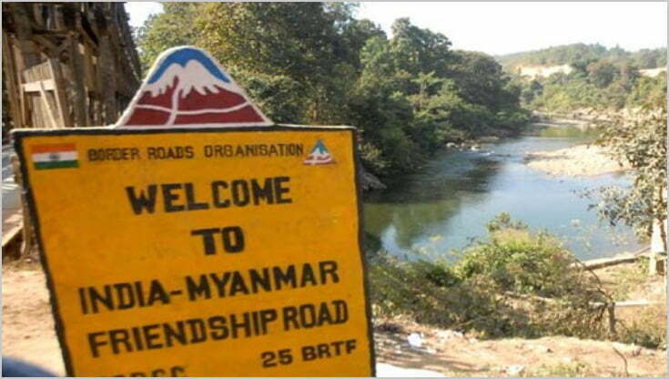
In the summer of 2026, as New Delhi seems to speed up its Rs 31,000-crore project to fence the 1,643-kilometre India-Myanmar frontier, a far more consequential subtext has emerged. There were also reports that the Government of India is reportedly examining a proposal to exchange approximately 1.4 square miles of territory near Manipur’s Chandel district—between border pillars 65 and 68—to expedite demarcation. The Ministry of External Affairs admits that “discussions are continuing on some unsettled sectors.”

While the government rushes to fence the border, the people in Manipur are worrying about their territorial integrity. Coordinating Committee on Manipur Integrity (COCOMI) had warned the Government of India against any move to transfer the territory of Manipur to Myanmar threatening mass agitation if the Centre attempts to do so.  COCOMI also expressed unhappiness over a MEA advisory dated 26 May, which gives a three-month time frame for demarcating the border, but makes no mention of any territorial gain for India. The organisation termed Manipur’s territorial integrity as “a red line” and said any move to shrink its boundaries would be opposed by the people of Manipur. Noting that there are stretches of disputed borders in Manipur, COCOMI said the situation is “particularly grave” in certain areas, such as BPs 64 and 68 at Molcham, 75 and 79 at Moreh and 88 and 95 at Choro Khunou. “The question also arises if India-Myanmar border talks and laying of auxiliary pillars in the Molcham sector are being done at the expense of Manipur’s territory,” COCOMI added.

For the ethnic communities whose ancestral lands straddle this frontier, the ambiguity is not diplomatic—it is existential. United Naga Council (UNC) in Manipur took the matter one step further by petitioning to the United Nations Permanent Forum on Indigenous Issues, demanding that they stop the so-called plan to give up indigenous ancestral territory and for the UN to intervene to enforce Free, Prior, and Informed Consent (FPIC).

However, it must be understood that the Indian administration has the legal leeway to redraw international boundaries without the consent of local communities due to the lack of a uniform definition of “border areas” and ambiguous legal mandates.

The Fence, the Exchange, the Unclear Demarcation

The Indian government has every reason to fence the border with Myanmar. Illegal immigration, weapon and drug trafficking, and the movement of insurgent groups and their weapons across the border prompted the Home Minister, Amit Shah, to state that this move would address “the root cause of the problem.” At the same time, it has become apparent that some of the border areas between India and Myanmar remain unsettled. The two countries signed the agreement on the border in 1967, but there are still “some unsettled sectors” along pillars 64-68 at Molcham, 75-79 at Moreh, and 88-95 at Choro Khunou. The government is considering exchanging territory to complete the demarcation in the sector of pillars 65-68 within a specified period.

The history of India’s borders with China and Myanmar shows that they were drawn based on an imperial framework. The border with Myanmar was defined in the Treaty of Yandaboo in 1826, which officially transferred Assam and Manipur to British rule. Later, in 1937, Burma was separated from India, dividing communities that had previously lived within the same administrative boundaries. The situation with China is similar, albeit more complicated, with the McMahon Line being another colonial inheritance. McMahon Line was initially opposed by the British government but was “reasserted in 1935 when Burma was separated from the Indian Empire.” The parallels between the India-China and India-Myanmar borders end with colonial roots. Each of them was imposed from outside, had ambiguous validity, and was applied unevenly.

The Legal Quick Sand of “Border Area”

India’s laws do not provide a uniform definition of border areas. In fact, the concept of border area is a fluid one, depending on the particular legal provisions. There are certain advantages to ambiguity as the Indian administration can adjust the borders as it sees fit. For example, the Border Security Force (BSF) Act, 1968 allows the central government to notify the areas within Manipur where the BSF has police powers. For most of the western states (Punjab, Gujarat, Rajasthan), the jurisdiction extends to 50 km from the border, but for Manipur, the entire state falls under the BSF’s jurisdiction. Since the BSF Act does not mention a “border belt” for Manipur, the Union Home Ministry has the power to take any action it considers necessary. Thus, if New Delhi decides to exchange the 1.4 square miles near the pillars 65-68, the BSF’s jurisdiction over Manipur will extend to the new border.

The lack of a uniform definition of a border area affects Manipur’s development in a more direct way. The Border Area Development Programme (BADP) is the only other national policy that mentions distance – 50 km from the border – in relation to Manipur. Within the first 10 km, developmental grants are provided for border villages under the BADP. The areas which will lose the land near the pillars 65-68 (Choro Khunou), or 75-79 (Moreh), and 88-95 (Choro Khunou) will no longer be eligible for developmental grants. There is no language in the BSF Act that obliges the Union government to consult Manipur’s legislative assembly or the local villagers before changing the border. Therefore, New Delhi can change the line between the international boundary and Manipur’s territory, adjusting the BADP coverage, without mentioning it anywhere. Manipur will bear the burden of the responsibility for increased security, while the benefits of development policy will be limited to a narrow strip within the first 10 km.

The Other Side of the Coin: Passport Act, ILP, and Frontier Exclusion

The Inner Line Permit (ILP) system dates back to the era of British rule in India. The rules were introduced in 1873 under the Bengal Eastern Frontier Regulation Act and were designed to protect British trade interests in Manipur. The Passport (Entry into India) Act, 1920, controls and regulates the entry of foreign citizens into India but does not specify where the “frontier” exactly extends. By introducing the ILP for the entire state of Manipur (notification issued in 2019) in addition to the BSF Act, New Delhi creates a border regime that excludes Manipur from the administrative and territorial integrity of India. First, the ILP permits foreigners to stay in Manipur, while Indians – even from neighboring states – need a permit. Second, the BSF Act restricts the movement of Myanmar nationals. However, neither the Passport Act nor the ILP system refers to the “frontier,” except for excluding foreigners from visiting Manipur. Thus, the residents of Manipur are trapped between the two laws that regulate the entry and exit of foreigners but do not consider the residents of Manipur, particularly those living within the first 50 km from the border, as citizens of the mainland.

The residents of Manipur are caught between the rules that prohibit them from visiting “foreign lands” and the rules that prevent “foreigners” from entering Manipur or even travelling within the state. At the same time, the government has the opportunity to “adjust the border” to tighten or loosen the rules for foreigners. The colonial framework, which separates Manipur from the rest of India, is also designed in such a way that the government can exclude certain areas and people from the general legal jurisdiction. This explains why the ILP system regulates entry into Manipur but does not prohibit Manipuris from exiting the state. New Delhi can “tighten the screws” by imposing stricter restrictions on the movement of Manipur citizens into neighbouring states, while “loosening the border” for other ethnic groups.

The Human Cost: Loss of Land, Loss of Kinship and Political Memory

The border between India and Myanmar is a “divide” that threatens to split communities that have lived together for generations. According to the Free Movement Regime (FMR), the residents of Manipur within the 40 km border belt could travel freely between the two countries without any documents. The FMR is being gradually withdrawn as the government tries to enforce stricter restrictions: the free movement now extends to 10 km, and the Indian administration plans to “notify the withdrawal of FMR altogether.”

Fencing the border and controlling the movement of people will lead to “loss of agricultural land, grazing land, paddy fields, rivers, sand resources and traditional hunting grounds.” Local villagers reported that India “had shifted a boundary pillar within their territory by about three km.”

The communities are already suffering from the consequences of the border, and the situation may deteriorate after years of tension between India and Myanmar. Since the military coup in Myanmar, more than 50,000 people have taken refuge in Mizoram and Manipur. The Indian government has little choice but to stop the influx of refugees, but the construction of the fence, as well as the withdrawal of the FMR, will cause irreparable damage.

The New Regime: Securitisation and Biometric Control

New Delhi is eager to impose a biometric security policy on the border. The draft Immigration and Foreigners Act, 2025 states that the new Act is intended to create a “new paradigm of border management” and replace “obsolescent laws.” New Delhi has developed a plan to create a “360-degree security environment for all border districts.” Recently, the authorities have taken steps to remove unauthorised structures within the 0-15 km belt. However, the very idea of ??the “new border regime” is doubtful since India’s laws on the management of border areas are based on colonial principles. The Passport Act 1920, which regulates travel to and from Manipur, was also enacted during the British Raj. The current laws on border security (BSF Act) were enacted in response to specific crises.

While the Indian government announced the dawn of a new era in border management, it is unclear how the new rules will affect the lives of border residents. There is no law specifically devoted to border demarcation and consultative procedures with local communities. At the same time, India’s Union government already faces disputes with some of the Northeastern states over jurisdiction.

The Legacy of the Partition Era

The proposed modification of the border between India and Myanmar poses considerable political risk for both countries. Manipur has suffered significantly from ethnic violence in recent years, and the government may find itself under pressure to revise the contested boundary. From India’s perspective, adopting this measure would make it possible to finalise the border, thereby completing the fencing project, shortening the border line, and reducing the opportunities for illegal crossings of armed groups. Additionally, improved relations with Myanmar will allow India to develop transport infrastructure and jointly combat armed insurgencies. However, it is essential to acknowledge that the imposition of borders without local community consent does not increase their security but may lead to other unforeseeable challenges.

(Dhiren A. Sadokpam is Editor-in-Chief, The Frontier Manipur)


The post Delhi’s Border Gambit in Manipur: Unravelling Colonial Cartography and Emerging Borderland Governance first appeared on The Frontier Manipur.

Read more / Original news source: https://thefrontiermanipur.com/delhis-border-gambit-in-manipur-unravelling-colonial-cartography-and-emerging-borderland-governance/
Delhi’s Border Gambit in Manipur: Unravelling Colonial Cartography and Emerging Borderland Governance

India’s laws do not provide a uniform definition of border areas. The concept of border area is a fluid one, depending on the particular legal provisions. There are certain advantages to ambiguity as the Indian administration can adjust the borders as it sees fit. The Border Security Force (BSF) Act, 1968 allows the central government […]

The post Delhi’s Border Gambit in Manipur: Unravelling Colonial Cartography and Emerging Borderland Governance first appeared on The Frontier Manipur.

India’s laws do not provide a uniform definition of border areas. The concept of border area is a fluid one, depending on the particular legal provisions. There are certain advantages to ambiguity as the Indian administration can adjust the borders as it sees fit. The Border Security Force (BSF) Act, 1968 allows the central government to notify the areas within Manipur where the BSF has police powers. For most of the western states (Punjab, Gujarat, Rajasthan), the jurisdiction extends to 50 km from the border, but for Manipur, the entire state falls under the BSF’s jurisdiction.

By Dhiren A. Sadokpam

In the summer of 2026, as New Delhi seems to speed up its Rs 31,000-crore project to fence the 1,643-kilometre India-Myanmar frontier, a far more consequential subtext has emerged. There were also reports that the Government of India is reportedly examining a proposal to exchange approximately 1.4 square miles of territory near Manipur’s Chandel district—between border pillars 65 and 68—to expedite demarcation. The Ministry of External Affairs admits that “discussions are continuing on some unsettled sectors.”

While the government rushes to fence the border, the people in Manipur are worrying about their territorial integrity. Coordinating Committee on Manipur Integrity (COCOMI) had warned the Government of India against any move to transfer the territory of Manipur to Myanmar threatening mass agitation if the Centre attempts to do so.  COCOMI also expressed unhappiness over a MEA advisory dated 26 May, which gives a three-month time frame for demarcating the border, but makes no mention of any territorial gain for India. The organisation termed Manipur’s territorial integrity as “a red line” and said any move to shrink its boundaries would be opposed by the people of Manipur. Noting that there are stretches of disputed borders in Manipur, COCOMI said the situation is “particularly grave” in certain areas, such as BPs 64 and 68 at Molcham, 75 and 79 at Moreh and 88 and 95 at Choro Khunou. “The question also arises if India-Myanmar border talks and laying of auxiliary pillars in the Molcham sector are being done at the expense of Manipur’s territory,” COCOMI added.

For the ethnic communities whose ancestral lands straddle this frontier, the ambiguity is not diplomatic—it is existential. United Naga Council (UNC) in Manipur took the matter one step further by petitioning to the United Nations Permanent Forum on Indigenous Issues, demanding that they stop the so-called plan to give up indigenous ancestral territory and for the UN to intervene to enforce Free, Prior, and Informed Consent (FPIC).

However, it must be understood that the Indian administration has the legal leeway to redraw international boundaries without the consent of local communities due to the lack of a uniform definition of “border areas” and ambiguous legal mandates.

The Fence, the Exchange, the Unclear Demarcation

The Indian government has every reason to fence the border with Myanmar. Illegal immigration, weapon and drug trafficking, and the movement of insurgent groups and their weapons across the border prompted the Home Minister, Amit Shah, to state that this move would address “the root cause of the problem.” At the same time, it has become apparent that some of the border areas between India and Myanmar remain unsettled. The two countries signed the agreement on the border in 1967, but there are still “some unsettled sectors” along pillars 64-68 at Molcham, 75-79 at Moreh, and 88-95 at Choro Khunou. The government is considering exchanging territory to complete the demarcation in the sector of pillars 65-68 within a specified period.

The history of India’s borders with China and Myanmar shows that they were drawn based on an imperial framework. The border with Myanmar was defined in the Treaty of Yandaboo in 1826, which officially transferred Assam and Manipur to British rule. Later, in 1937, Burma was separated from India, dividing communities that had previously lived within the same administrative boundaries. The situation with China is similar, albeit more complicated, with the McMahon Line being another colonial inheritance. McMahon Line was initially opposed by the British government but was “reasserted in 1935 when Burma was separated from the Indian Empire.” The parallels between the India-China and India-Myanmar borders end with colonial roots. Each of them was imposed from outside, had ambiguous validity, and was applied unevenly.

The Legal Quick Sand of “Border Area”

India’s laws do not provide a uniform definition of border areas. In fact, the concept of border area is a fluid one, depending on the particular legal provisions. There are certain advantages to ambiguity as the Indian administration can adjust the borders as it sees fit. For example, the Border Security Force (BSF) Act, 1968 allows the central government to notify the areas within Manipur where the BSF has police powers. For most of the western states (Punjab, Gujarat, Rajasthan), the jurisdiction extends to 50 km from the border, but for Manipur, the entire state falls under the BSF’s jurisdiction. Since the BSF Act does not mention a “border belt” for Manipur, the Union Home Ministry has the power to take any action it considers necessary. Thus, if New Delhi decides to exchange the 1.4 square miles near the pillars 65-68, the BSF’s jurisdiction over Manipur will extend to the new border.

The lack of a uniform definition of a border area affects Manipur’s development in a more direct way. The Border Area Development Programme (BADP) is the only other national policy that mentions distance – 50 km from the border – in relation to Manipur. Within the first 10 km, developmental grants are provided for border villages under the BADP. The areas which will lose the land near the pillars 65-68 (Choro Khunou), or 75-79 (Moreh), and 88-95 (Choro Khunou) will no longer be eligible for developmental grants. There is no language in the BSF Act that obliges the Union government to consult Manipur’s legislative assembly or the local villagers before changing the border. Therefore, New Delhi can change the line between the international boundary and Manipur’s territory, adjusting the BADP coverage, without mentioning it anywhere. Manipur will bear the burden of the responsibility for increased security, while the benefits of development policy will be limited to a narrow strip within the first 10 km.

The Other Side of the Coin: Passport Act, ILP, and Frontier Exclusion

The Inner Line Permit (ILP) system dates back to the era of British rule in India. The rules were introduced in 1873 under the Bengal Eastern Frontier Regulation Act and were designed to protect British trade interests in Manipur. The Passport (Entry into India) Act, 1920, controls and regulates the entry of foreign citizens into India but does not specify where the “frontier” exactly extends. By introducing the ILP for the entire state of Manipur (notification issued in 2019) in addition to the BSF Act, New Delhi creates a border regime that excludes Manipur from the administrative and territorial integrity of India. First, the ILP permits foreigners to stay in Manipur, while Indians – even from neighboring states – need a permit. Second, the BSF Act restricts the movement of Myanmar nationals. However, neither the Passport Act nor the ILP system refers to the “frontier,” except for excluding foreigners from visiting Manipur. Thus, the residents of Manipur are trapped between the two laws that regulate the entry and exit of foreigners but do not consider the residents of Manipur, particularly those living within the first 50 km from the border, as citizens of the mainland.

The residents of Manipur are caught between the rules that prohibit them from visiting “foreign lands” and the rules that prevent “foreigners” from entering Manipur or even travelling within the state. At the same time, the government has the opportunity to “adjust the border” to tighten or loosen the rules for foreigners. The colonial framework, which separates Manipur from the rest of India, is also designed in such a way that the government can exclude certain areas and people from the general legal jurisdiction. This explains why the ILP system regulates entry into Manipur but does not prohibit Manipuris from exiting the state. New Delhi can “tighten the screws” by imposing stricter restrictions on the movement of Manipur citizens into neighbouring states, while “loosening the border” for other ethnic groups.

The Human Cost: Loss of Land, Loss of Kinship and Political Memory

The border between India and Myanmar is a “divide” that threatens to split communities that have lived together for generations. According to the Free Movement Regime (FMR), the residents of Manipur within the 40 km border belt could travel freely between the two countries without any documents. The FMR is being gradually withdrawn as the government tries to enforce stricter restrictions: the free movement now extends to 10 km, and the Indian administration plans to “notify the withdrawal of FMR altogether.”

Fencing the border and controlling the movement of people will lead to “loss of agricultural land, grazing land, paddy fields, rivers, sand resources and traditional hunting grounds.” Local villagers reported that India “had shifted a boundary pillar within their territory by about three km.”

The communities are already suffering from the consequences of the border, and the situation may deteriorate after years of tension between India and Myanmar. Since the military coup in Myanmar, more than 50,000 people have taken refuge in Mizoram and Manipur. The Indian government has little choice but to stop the influx of refugees, but the construction of the fence, as well as the withdrawal of the FMR, will cause irreparable damage.

The New Regime: Securitisation and Biometric Control

New Delhi is eager to impose a biometric security policy on the border. The draft Immigration and Foreigners Act, 2025 states that the new Act is intended to create a “new paradigm of border management” and replace “obsolescent laws.” New Delhi has developed a plan to create a “360-degree security environment for all border districts.” Recently, the authorities have taken steps to remove unauthorised structures within the 0-15 km belt. However, the very idea of ??the “new border regime” is doubtful since India’s laws on the management of border areas are based on colonial principles. The Passport Act 1920, which regulates travel to and from Manipur, was also enacted during the British Raj. The current laws on border security (BSF Act) were enacted in response to specific crises.

While the Indian government announced the dawn of a new era in border management, it is unclear how the new rules will affect the lives of border residents. There is no law specifically devoted to border demarcation and consultative procedures with local communities. At the same time, India’s Union government already faces disputes with some of the Northeastern states over jurisdiction.

The Legacy of the Partition Era

The proposed modification of the border between India and Myanmar poses considerable political risk for both countries. Manipur has suffered significantly from ethnic violence in recent years, and the government may find itself under pressure to revise the contested boundary. From India’s perspective, adopting this measure would make it possible to finalise the border, thereby completing the fencing project, shortening the border line, and reducing the opportunities for illegal crossings of armed groups. Additionally, improved relations with Myanmar will allow India to develop transport infrastructure and jointly combat armed insurgencies. However, it is essential to acknowledge that the imposition of borders without local community consent does not increase their security but may lead to other unforeseeable challenges.

(Dhiren A. Sadokpam is Editor-in-Chief, The Frontier Manipur)


The post Delhi’s Border Gambit in Manipur: Unravelling Colonial Cartography and Emerging Borderland Governance first appeared on The Frontier Manipur.

Read more / Original news source: https://thefrontiermanipur.com/delhis-border-gambit-in-manipur-unravelling-colonial-cartography-and-emerging-borderland-governance/

Delhi’s Border Gambit in Manipur: Unravelling Colonial Cartography and Emerging Borderland Governance

India’s laws do not provide a uniform definition of border areas. The concept of border area is a fluid one, depending on the particular legal provisions. There are certain advantages to ambiguity as the Indian administration can adjust the borders as it sees fit. The Border Security Force (BSF) Act, 1968 allows the central government […]

The post Delhi’s Border Gambit in Manipur: Unravelling Colonial Cartography and Emerging Borderland Governance first appeared on The Frontier Manipur.

India’s laws do not provide a uniform definition of border areas. The concept of border area is a fluid one, depending on the particular legal provisions. There are certain advantages to ambiguity as the Indian administration can adjust the borders as it sees fit. The Border Security Force (BSF) Act, 1968 allows the central government to notify the areas within Manipur where the BSF has police powers. For most of the western states (Punjab, Gujarat, Rajasthan), the jurisdiction extends to 50 km from the border, but for Manipur, the entire state falls under the BSF’s jurisdiction.

By Dhiren A. Sadokpam

In the summer of 2026, as New Delhi seems to speed up its Rs 31,000-crore project to fence the 1,643-kilometre India-Myanmar frontier, a far more consequential subtext has emerged. There were also reports that the Government of India is reportedly examining a proposal to exchange approximately 1.4 square miles of territory near Manipur’s Chandel district—between border pillars 65 and 68—to expedite demarcation. The Ministry of External Affairs admits that “discussions are continuing on some unsettled sectors.”

While the government rushes to fence the border, the people in Manipur are worrying about their territorial integrity. Coordinating Committee on Manipur Integrity (COCOMI) had warned the Government of India against any move to transfer the territory of Manipur to Myanmar threatening mass agitation if the Centre attempts to do so.  COCOMI also expressed unhappiness over a MEA advisory dated 26 May, which gives a three-month time frame for demarcating the border, but makes no mention of any territorial gain for India. The organisation termed Manipur’s territorial integrity as “a red line” and said any move to shrink its boundaries would be opposed by the people of Manipur. Noting that there are stretches of disputed borders in Manipur, COCOMI said the situation is “particularly grave” in certain areas, such as BPs 64 and 68 at Molcham, 75 and 79 at Moreh and 88 and 95 at Choro Khunou. “The question also arises if India-Myanmar border talks and laying of auxiliary pillars in the Molcham sector are being done at the expense of Manipur’s territory,” COCOMI added.

For the ethnic communities whose ancestral lands straddle this frontier, the ambiguity is not diplomatic—it is existential. United Naga Council (UNC) in Manipur took the matter one step further by petitioning to the United Nations Permanent Forum on Indigenous Issues, demanding that they stop the so-called plan to give up indigenous ancestral territory and for the UN to intervene to enforce Free, Prior, and Informed Consent (FPIC).

However, it must be understood that the Indian administration has the legal leeway to redraw international boundaries without the consent of local communities due to the lack of a uniform definition of “border areas” and ambiguous legal mandates.

The Fence, the Exchange, the Unclear Demarcation

The Indian government has every reason to fence the border with Myanmar. Illegal immigration, weapon and drug trafficking, and the movement of insurgent groups and their weapons across the border prompted the Home Minister, Amit Shah, to state that this move would address “the root cause of the problem.” At the same time, it has become apparent that some of the border areas between India and Myanmar remain unsettled. The two countries signed the agreement on the border in 1967, but there are still “some unsettled sectors” along pillars 64-68 at Molcham, 75-79 at Moreh, and 88-95 at Choro Khunou. The government is considering exchanging territory to complete the demarcation in the sector of pillars 65-68 within a specified period.

The history of India’s borders with China and Myanmar shows that they were drawn based on an imperial framework. The border with Myanmar was defined in the Treaty of Yandaboo in 1826, which officially transferred Assam and Manipur to British rule. Later, in 1937, Burma was separated from India, dividing communities that had previously lived within the same administrative boundaries. The situation with China is similar, albeit more complicated, with the McMahon Line being another colonial inheritance. McMahon Line was initially opposed by the British government but was “reasserted in 1935 when Burma was separated from the Indian Empire.” The parallels between the India-China and India-Myanmar borders end with colonial roots. Each of them was imposed from outside, had ambiguous validity, and was applied unevenly.

The Legal Quick Sand of “Border Area”

India’s laws do not provide a uniform definition of border areas. In fact, the concept of border area is a fluid one, depending on the particular legal provisions. There are certain advantages to ambiguity as the Indian administration can adjust the borders as it sees fit. For example, the Border Security Force (BSF) Act, 1968 allows the central government to notify the areas within Manipur where the BSF has police powers. For most of the western states (Punjab, Gujarat, Rajasthan), the jurisdiction extends to 50 km from the border, but for Manipur, the entire state falls under the BSF’s jurisdiction. Since the BSF Act does not mention a “border belt” for Manipur, the Union Home Ministry has the power to take any action it considers necessary. Thus, if New Delhi decides to exchange the 1.4 square miles near the pillars 65-68, the BSF’s jurisdiction over Manipur will extend to the new border.

The lack of a uniform definition of a border area affects Manipur’s development in a more direct way. The Border Area Development Programme (BADP) is the only other national policy that mentions distance – 50 km from the border – in relation to Manipur. Within the first 10 km, developmental grants are provided for border villages under the BADP. The areas which will lose the land near the pillars 65-68 (Choro Khunou), or 75-79 (Moreh), and 88-95 (Choro Khunou) will no longer be eligible for developmental grants. There is no language in the BSF Act that obliges the Union government to consult Manipur’s legislative assembly or the local villagers before changing the border. Therefore, New Delhi can change the line between the international boundary and Manipur’s territory, adjusting the BADP coverage, without mentioning it anywhere. Manipur will bear the burden of the responsibility for increased security, while the benefits of development policy will be limited to a narrow strip within the first 10 km.

The Other Side of the Coin: Passport Act, ILP, and Frontier Exclusion

The Inner Line Permit (ILP) system dates back to the era of British rule in India. The rules were introduced in 1873 under the Bengal Eastern Frontier Regulation Act and were designed to protect British trade interests in Manipur. The Passport (Entry into India) Act, 1920, controls and regulates the entry of foreign citizens into India but does not specify where the “frontier” exactly extends. By introducing the ILP for the entire state of Manipur (notification issued in 2019) in addition to the BSF Act, New Delhi creates a border regime that excludes Manipur from the administrative and territorial integrity of India. First, the ILP permits foreigners to stay in Manipur, while Indians – even from neighboring states – need a permit. Second, the BSF Act restricts the movement of Myanmar nationals. However, neither the Passport Act nor the ILP system refers to the “frontier,” except for excluding foreigners from visiting Manipur. Thus, the residents of Manipur are trapped between the two laws that regulate the entry and exit of foreigners but do not consider the residents of Manipur, particularly those living within the first 50 km from the border, as citizens of the mainland.

The residents of Manipur are caught between the rules that prohibit them from visiting “foreign lands” and the rules that prevent “foreigners” from entering Manipur or even travelling within the state. At the same time, the government has the opportunity to “adjust the border” to tighten or loosen the rules for foreigners. The colonial framework, which separates Manipur from the rest of India, is also designed in such a way that the government can exclude certain areas and people from the general legal jurisdiction. This explains why the ILP system regulates entry into Manipur but does not prohibit Manipuris from exiting the state. New Delhi can “tighten the screws” by imposing stricter restrictions on the movement of Manipur citizens into neighbouring states, while “loosening the border” for other ethnic groups.

The Human Cost: Loss of Land, Loss of Kinship and Political Memory

The border between India and Myanmar is a “divide” that threatens to split communities that have lived together for generations. According to the Free Movement Regime (FMR), the residents of Manipur within the 40 km border belt could travel freely between the two countries without any documents. The FMR is being gradually withdrawn as the government tries to enforce stricter restrictions: the free movement now extends to 10 km, and the Indian administration plans to “notify the withdrawal of FMR altogether.”

Fencing the border and controlling the movement of people will lead to “loss of agricultural land, grazing land, paddy fields, rivers, sand resources and traditional hunting grounds.” Local villagers reported that India “had shifted a boundary pillar within their territory by about three km.”

The communities are already suffering from the consequences of the border, and the situation may deteriorate after years of tension between India and Myanmar. Since the military coup in Myanmar, more than 50,000 people have taken refuge in Mizoram and Manipur. The Indian government has little choice but to stop the influx of refugees, but the construction of the fence, as well as the withdrawal of the FMR, will cause irreparable damage.

The New Regime: Securitisation and Biometric Control

New Delhi is eager to impose a biometric security policy on the border. The draft Immigration and Foreigners Act, 2025 states that the new Act is intended to create a “new paradigm of border management” and replace “obsolescent laws.” New Delhi has developed a plan to create a “360-degree security environment for all border districts.” Recently, the authorities have taken steps to remove unauthorised structures within the 0-15 km belt. However, the very idea of ??the “new border regime” is doubtful since India’s laws on the management of border areas are based on colonial principles. The Passport Act 1920, which regulates travel to and from Manipur, was also enacted during the British Raj. The current laws on border security (BSF Act) were enacted in response to specific crises.

While the Indian government announced the dawn of a new era in border management, it is unclear how the new rules will affect the lives of border residents. There is no law specifically devoted to border demarcation and consultative procedures with local communities. At the same time, India’s Union government already faces disputes with some of the Northeastern states over jurisdiction.

The Legacy of the Partition Era

The proposed modification of the border between India and Myanmar poses considerable political risk for both countries. Manipur has suffered significantly from ethnic violence in recent years, and the government may find itself under pressure to revise the contested boundary. From India’s perspective, adopting this measure would make it possible to finalise the border, thereby completing the fencing project, shortening the border line, and reducing the opportunities for illegal crossings of armed groups. Additionally, improved relations with Myanmar will allow India to develop transport infrastructure and jointly combat armed insurgencies. However, it is essential to acknowledge that the imposition of borders without local community consent does not increase their security but may lead to other unforeseeable challenges.

(Dhiren A. Sadokpam is Editor-in-Chief, The Frontier Manipur)


The post Delhi’s Border Gambit in Manipur: Unravelling Colonial Cartography and Emerging Borderland Governance first appeared on The Frontier Manipur.

Read more / Original news source: https://thefrontiermanipur.com/delhis-border-gambit-in-manipur-unravelling-colonial-cartography-and-emerging-borderland-governance/

Delhi’s Border Gambit in Manipur: Unravelling Colonial Cartography and Emerging Borderland Governance

India’s laws do not provide a uniform definition of border areas. The concept of border area is a fluid one, depending on the particular legal provisions. There are certain advantages to ambiguity as the Indian administration can adjust the borders as it sees fit. The Border Security Force (BSF) Act, 1968 allows the central government […]

The post Delhi’s Border Gambit in Manipur: Unravelling Colonial Cartography and Emerging Borderland Governance first appeared on The Frontier Manipur.

India’s laws do not provide a uniform definition of border areas. The concept of border area is a fluid one, depending on the particular legal provisions. There are certain advantages to ambiguity as the Indian administration can adjust the borders as it sees fit. The Border Security Force (BSF) Act, 1968 allows the central government to notify the areas within Manipur where the BSF has police powers. For most of the western states (Punjab, Gujarat, Rajasthan), the jurisdiction extends to 50 km from the border, but for Manipur, the entire state falls under the BSF’s jurisdiction.

By Dhiren A. Sadokpam

In the summer of 2026, as New Delhi seems to speed up its Rs 31,000-crore project to fence the 1,643-kilometre India-Myanmar frontier, a far more consequential subtext has emerged. There were also reports that the Government of India is reportedly examining a proposal to exchange approximately 1.4 square miles of territory near Manipur’s Chandel district—between border pillars 65 and 68—to expedite demarcation. The Ministry of External Affairs admits that “discussions are continuing on some unsettled sectors.”

While the government rushes to fence the border, the people in Manipur are worrying about their territorial integrity. Coordinating Committee on Manipur Integrity (COCOMI) had warned the Government of India against any move to transfer the territory of Manipur to Myanmar threatening mass agitation if the Centre attempts to do so.  COCOMI also expressed unhappiness over a MEA advisory dated 26 May, which gives a three-month time frame for demarcating the border, but makes no mention of any territorial gain for India. The organisation termed Manipur’s territorial integrity as “a red line” and said any move to shrink its boundaries would be opposed by the people of Manipur. Noting that there are stretches of disputed borders in Manipur, COCOMI said the situation is “particularly grave” in certain areas, such as BPs 64 and 68 at Molcham, 75 and 79 at Moreh and 88 and 95 at Choro Khunou. “The question also arises if India-Myanmar border talks and laying of auxiliary pillars in the Molcham sector are being done at the expense of Manipur’s territory,” COCOMI added.

For the ethnic communities whose ancestral lands straddle this frontier, the ambiguity is not diplomatic—it is existential. United Naga Council (UNC) in Manipur took the matter one step further by petitioning to the United Nations Permanent Forum on Indigenous Issues, demanding that they stop the so-called plan to give up indigenous ancestral territory and for the UN to intervene to enforce Free, Prior, and Informed Consent (FPIC).

However, it must be understood that the Indian administration has the legal leeway to redraw international boundaries without the consent of local communities due to the lack of a uniform definition of “border areas” and ambiguous legal mandates.

The Fence, the Exchange, the Unclear Demarcation

The Indian government has every reason to fence the border with Myanmar. Illegal immigration, weapon and drug trafficking, and the movement of insurgent groups and their weapons across the border prompted the Home Minister, Amit Shah, to state that this move would address “the root cause of the problem.” At the same time, it has become apparent that some of the border areas between India and Myanmar remain unsettled. The two countries signed the agreement on the border in 1967, but there are still “some unsettled sectors” along pillars 64-68 at Molcham, 75-79 at Moreh, and 88-95 at Choro Khunou. The government is considering exchanging territory to complete the demarcation in the sector of pillars 65-68 within a specified period.

The history of India’s borders with China and Myanmar shows that they were drawn based on an imperial framework. The border with Myanmar was defined in the Treaty of Yandaboo in 1826, which officially transferred Assam and Manipur to British rule. Later, in 1937, Burma was separated from India, dividing communities that had previously lived within the same administrative boundaries. The situation with China is similar, albeit more complicated, with the McMahon Line being another colonial inheritance. McMahon Line was initially opposed by the British government but was “reasserted in 1935 when Burma was separated from the Indian Empire.” The parallels between the India-China and India-Myanmar borders end with colonial roots. Each of them was imposed from outside, had ambiguous validity, and was applied unevenly.

The Legal Quick Sand of “Border Area”

India’s laws do not provide a uniform definition of border areas. In fact, the concept of border area is a fluid one, depending on the particular legal provisions. There are certain advantages to ambiguity as the Indian administration can adjust the borders as it sees fit. For example, the Border Security Force (BSF) Act, 1968 allows the central government to notify the areas within Manipur where the BSF has police powers. For most of the western states (Punjab, Gujarat, Rajasthan), the jurisdiction extends to 50 km from the border, but for Manipur, the entire state falls under the BSF’s jurisdiction. Since the BSF Act does not mention a “border belt” for Manipur, the Union Home Ministry has the power to take any action it considers necessary. Thus, if New Delhi decides to exchange the 1.4 square miles near the pillars 65-68, the BSF’s jurisdiction over Manipur will extend to the new border.

The lack of a uniform definition of a border area affects Manipur’s development in a more direct way. The Border Area Development Programme (BADP) is the only other national policy that mentions distance – 50 km from the border – in relation to Manipur. Within the first 10 km, developmental grants are provided for border villages under the BADP. The areas which will lose the land near the pillars 65-68 (Choro Khunou), or 75-79 (Moreh), and 88-95 (Choro Khunou) will no longer be eligible for developmental grants. There is no language in the BSF Act that obliges the Union government to consult Manipur’s legislative assembly or the local villagers before changing the border. Therefore, New Delhi can change the line between the international boundary and Manipur’s territory, adjusting the BADP coverage, without mentioning it anywhere. Manipur will bear the burden of the responsibility for increased security, while the benefits of development policy will be limited to a narrow strip within the first 10 km.

The Other Side of the Coin: Passport Act, ILP, and Frontier Exclusion

The Inner Line Permit (ILP) system dates back to the era of British rule in India. The rules were introduced in 1873 under the Bengal Eastern Frontier Regulation Act and were designed to protect British trade interests in Manipur. The Passport (Entry into India) Act, 1920, controls and regulates the entry of foreign citizens into India but does not specify where the “frontier” exactly extends. By introducing the ILP for the entire state of Manipur (notification issued in 2019) in addition to the BSF Act, New Delhi creates a border regime that excludes Manipur from the administrative and territorial integrity of India. First, the ILP permits foreigners to stay in Manipur, while Indians – even from neighboring states – need a permit. Second, the BSF Act restricts the movement of Myanmar nationals. However, neither the Passport Act nor the ILP system refers to the “frontier,” except for excluding foreigners from visiting Manipur. Thus, the residents of Manipur are trapped between the two laws that regulate the entry and exit of foreigners but do not consider the residents of Manipur, particularly those living within the first 50 km from the border, as citizens of the mainland.

The residents of Manipur are caught between the rules that prohibit them from visiting “foreign lands” and the rules that prevent “foreigners” from entering Manipur or even travelling within the state. At the same time, the government has the opportunity to “adjust the border” to tighten or loosen the rules for foreigners. The colonial framework, which separates Manipur from the rest of India, is also designed in such a way that the government can exclude certain areas and people from the general legal jurisdiction. This explains why the ILP system regulates entry into Manipur but does not prohibit Manipuris from exiting the state. New Delhi can “tighten the screws” by imposing stricter restrictions on the movement of Manipur citizens into neighbouring states, while “loosening the border” for other ethnic groups.

The Human Cost: Loss of Land, Loss of Kinship and Political Memory

The border between India and Myanmar is a “divide” that threatens to split communities that have lived together for generations. According to the Free Movement Regime (FMR), the residents of Manipur within the 40 km border belt could travel freely between the two countries without any documents. The FMR is being gradually withdrawn as the government tries to enforce stricter restrictions: the free movement now extends to 10 km, and the Indian administration plans to “notify the withdrawal of FMR altogether.”

Fencing the border and controlling the movement of people will lead to “loss of agricultural land, grazing land, paddy fields, rivers, sand resources and traditional hunting grounds.” Local villagers reported that India “had shifted a boundary pillar within their territory by about three km.”

The communities are already suffering from the consequences of the border, and the situation may deteriorate after years of tension between India and Myanmar. Since the military coup in Myanmar, more than 50,000 people have taken refuge in Mizoram and Manipur. The Indian government has little choice but to stop the influx of refugees, but the construction of the fence, as well as the withdrawal of the FMR, will cause irreparable damage.

The New Regime: Securitisation and Biometric Control

New Delhi is eager to impose a biometric security policy on the border. The draft Immigration and Foreigners Act, 2025 states that the new Act is intended to create a “new paradigm of border management” and replace “obsolescent laws.” New Delhi has developed a plan to create a “360-degree security environment for all border districts.” Recently, the authorities have taken steps to remove unauthorised structures within the 0-15 km belt. However, the very idea of ??the “new border regime” is doubtful since India’s laws on the management of border areas are based on colonial principles. The Passport Act 1920, which regulates travel to and from Manipur, was also enacted during the British Raj. The current laws on border security (BSF Act) were enacted in response to specific crises.

While the Indian government announced the dawn of a new era in border management, it is unclear how the new rules will affect the lives of border residents. There is no law specifically devoted to border demarcation and consultative procedures with local communities. At the same time, India’s Union government already faces disputes with some of the Northeastern states over jurisdiction.

The Legacy of the Partition Era

The proposed modification of the border between India and Myanmar poses considerable political risk for both countries. Manipur has suffered significantly from ethnic violence in recent years, and the government may find itself under pressure to revise the contested boundary. From India’s perspective, adopting this measure would make it possible to finalise the border, thereby completing the fencing project, shortening the border line, and reducing the opportunities for illegal crossings of armed groups. Additionally, improved relations with Myanmar will allow India to develop transport infrastructure and jointly combat armed insurgencies. However, it is essential to acknowledge that the imposition of borders without local community consent does not increase their security but may lead to other unforeseeable challenges.

(Dhiren A. Sadokpam is Editor-in-Chief, The Frontier Manipur)


The post Delhi’s Border Gambit in Manipur: Unravelling Colonial Cartography and Emerging Borderland Governance first appeared on The Frontier Manipur.

Read more / Original news source: https://thefrontiermanipur.com/delhis-border-gambit-in-manipur-unravelling-colonial-cartography-and-emerging-borderland-governance/

Why the Manipur Government Has No Power in the Hills: A Simple Explanation Using Weber and Foucault

Here is the puzzle of Manipur in plain terms: the state government seems to rules the valley, but it does not rule the hills. The state can arrest someone in Imphal valley within minutes, but it cannot do the same in a hill village. Two famous thinkers—Max Weber and Michel Foucault—help us understand why this […]

The post Why the Manipur Government Has No Power in the Hills: A Simple Explanation Using Weber and Foucault first appeared on The Frontier Manipur.

Here is the puzzle of Manipur in plain terms: the state government seems to rules the valley, but it does not rule the hills. The state can arrest someone in Imphal valley within minutes, but it cannot do the same in a hill village. Two famous thinkers—Max Weber and Michel Foucault—help us understand why this happens and what it means.

By KH. Ibomcha

Part One: Weber and the Monopoly on Violence

Max Weber, the German sociologist who lived from 1864 to 1920, gave us one of the most important definitions of what a state actually is.

Weber said: a state is that human community which successfully claims the monopoly of the legitimate use of physical force within a given territory. In simpler words, only the state has the legal right to use force—to send police, to arrest people, to put them in jail. No one else should be allowed to do this. This is what makes a state a state.

The key word here is “legitimate.” It does not mean the state is the only one actually using violence. Criminal gangs use violence too. But only the state can say: “We have the right to use force, and you do not.” The state can even allow private actors to use force, as long as they get the legal sanction or not from the state. Think of self-defense: you can use force to protect yourself, but only because the state recognizes that right.

Weber also said that territory matters. The state’s authority only makes sense within a defined area. The state can use force, but only in its own jurisdiction.

Now here is the problem in Manipur. In the valley, the state has this monopoly. If there is a protest in Imphal valley, police arrive in minutes. They impose legal provisions, arrest people, and control the situation. The state shows it can use legitimate force.

But in the hills and elsewhere in Manipur’s periphery, this monopoly does not exist. There, armed groups collect tax on highways. They decide who can pass. They punish people. They run their own courts. The state’s police station may exist, but it is locked inside the compound. It does not patrol. It does not act. So legitimate violence has not climbed the peripheries or the hills. Instead, illegitimate violence has taken its place.

Weber would say: when the state loses its monopoly on legitimate violence in part of its territory, it is no longer fully a state in that area. It becomes something less.

Part Two: Foucault and Governmentality

Michel Foucault, the French philosopher who died in 1984,  gave us a different way to think about power. Foucault said: power is not just guns and laws. Power is daily work.

He used the word “governmentality” to describe the art of governing people through daily techniques. Governmentality is not about big speeches or grand ceremonies. It is about boring, repetitive work: the constable doing his beat, the clerk updating land records, the population enumerator knocking on doors, the court issuing summons.

Foucault also used the word “dispositif.” This means the whole apparatus of government: offices, files, policing methods, census, surveillance, records, and the way people talk about these things. The dispositif is the machine that makes government work every day.

In the valley, there is a spectacle that makes some people believe that this machine works. Foucault would call it “panoptic”—like a CCTV that is always on. The state watches. It seems to know. It seems to record. It punishes quickly. People become visible to the state- either as the people to be ruled or mere subjects. They become seemingly governable.

In the hills, this machine seems to have failed. The gaze does not reach. The hills are zones of opacity—dark spots where the state cannot see. The state does not know who lives where, who came when, what is grown in which field. Foucault had a term for this: “power/knowledge.” Knowing is power. If the state does not know the hills, it cannot govern them.

What the state does instead in the hills are “simulacra”—fake shows of governance. A minister comes by helicopter. He gives a speech. He inaugurates a building. He eats lunch. He leaves. This looks like government on TV. But it is not governmentality. Real governmentality is daily, not ceremonial.

Part Three: What Happens When Governmentality Is Absent

When state governmentality is absent, other authorities grow. They produce their own power/knowledge. They produce their own discipline. The state is no longer the only boss. These are what we call de facto sovereignties—authorities that act like governments even though they are not the official government.

Now the state government wants to conduct NRC exercise and census. In Foucault’s language, these are “biopolitical tools”—tools to manage population, to classify who belongs and who does not. Biopolitics is about managing life itself: births, deaths, health, residency, identity.

But biopolitical tools only work if disciplinary techniques already exist on the ground. If your police cannot go to a hill village to verify a document, if your office has no old records, then who will make the NRC list? Local actors will make it. They will include who they want. They will exclude who they do not want.

Foucault would call this “epistemic capture”—when the process of producing knowledge is captured by local power-holders via the Union government. The state thinks it is making a list. But actually, local actors are behind in making the list. The state is just signing off on it.

So a list made by a state in absentia does not necessarily be accepted as truth. It will create more fight, not less.

Part Four: What Would It Mean to Actually Govern the Hills?

“Chingda Chatsi” (translated as “Let’s Go to the Hills”) hills does not mean sending more army or more AFSPA. Going to the hills means extending legitimate force in its disciplinary, lawful form. It means extending what Foucault called “disciplinary puissance”—the capacity to enforce laws every day, not just in raids.

Here is what that would look like: First, daily beat policing. Not raid-based policing. An FIR can be filed in Churachandpur as easily as in Imphal. Investigation happens by law, not by permission from armed groups.

Second, rebuilding epistemic infrastructure. This means restoring the daily files, land records, and residency records so that the state can actually know the hills. Without knowing, it cannot govern.

Third, moving from spectacle to praxis. This means shifting from one-day visits to everyday presence. A Deputy Commissioner or a Superintendent of Police who actually live in the hill district, who hold daily hearings, could begin to make governmentality take root.

If the Manipur state cannot do this because it is too weak, too communalised/ethnicised, or too compromised, then it must ask for a reconfiguration of the dispositif. In simple legal terms: ask the Centre to reconfigure jurisdiction under one command structure that is seen as neutral and accountable.

Otherwise, Manipur will remain what it is—a state with a bifurcated or trifurcated authorities, one panopticon that works in the valley and is switched off in the hills.

Weber would say: first become a state everywhere. Foucault would say: first establish your governmentality everywhere. Only when legitimate violence and the knowledge that makes it legitimate have both climbed the hills can peace have a chance.

(Kh Ibomcha is a social and political commentator. He has contributed many critical articles in the regional media)

The post Why the Manipur Government Has No Power in the Hills: A Simple Explanation Using Weber and Foucault first appeared on The Frontier Manipur.

Read more / Original news source: https://thefrontiermanipur.com/why-the-manipur-government-has-no-power-in-the-hills-a-simple-explanation-using-weber-and-foucault/

Why the Manipur Government Has No Power in the Hills: A Simple Explanation Using Weber and Foucault

Here is the puzzle of Manipur in plain terms: the state government seems to rules the valley, but it does not rule the hills. The state can arrest someone in Imphal valley within minutes, but it cannot do the same in a hill village. Two famous thinkers—Max Weber and Michel Foucault—help us understand why this […]

The post Why the Manipur Government Has No Power in the Hills: A Simple Explanation Using Weber and Foucault first appeared on The Frontier Manipur.

Here is the puzzle of Manipur in plain terms: the state government seems to rules the valley, but it does not rule the hills. The state can arrest someone in Imphal valley within minutes, but it cannot do the same in a hill village. Two famous thinkers—Max Weber and Michel Foucault—help us understand why this happens and what it means.

By KH. Ibomcha

Part One: Weber and the Monopoly on Violence

Max Weber, the German sociologist who lived from 1864 to 1920, gave us one of the most important definitions of what a state actually is.

Weber said: a state is that human community which successfully claims the monopoly of the legitimate use of physical force within a given territory. In simpler words, only the state has the legal right to use force—to send police, to arrest people, to put them in jail. No one else should be allowed to do this. This is what makes a state a state.

The key word here is “legitimate.” It does not mean the state is the only one actually using violence. Criminal gangs use violence too. But only the state can say: “We have the right to use force, and you do not.” The state can even allow private actors to use force, as long as they get the legal sanction or not from the state. Think of self-defense: you can use force to protect yourself, but only because the state recognizes that right.

Weber also said that territory matters. The state’s authority only makes sense within a defined area. The state can use force, but only in its own jurisdiction.

Now here is the problem in Manipur. In the valley, the state has this monopoly. If there is a protest in Imphal valley, police arrive in minutes. They impose legal provisions, arrest people, and control the situation. The state shows it can use legitimate force.

But in the hills and elsewhere in Manipur’s periphery, this monopoly does not exist. There, armed groups collect tax on highways. They decide who can pass. They punish people. They run their own courts. The state’s police station may exist, but it is locked inside the compound. It does not patrol. It does not act. So legitimate violence has not climbed the peripheries or the hills. Instead, illegitimate violence has taken its place.

Weber would say: when the state loses its monopoly on legitimate violence in part of its territory, it is no longer fully a state in that area. It becomes something less.

Part Two: Foucault and Governmentality

Michel Foucault, the French philosopher who died in 1984,  gave us a different way to think about power. Foucault said: power is not just guns and laws. Power is daily work.

He used the word “governmentality” to describe the art of governing people through daily techniques. Governmentality is not about big speeches or grand ceremonies. It is about boring, repetitive work: the constable doing his beat, the clerk updating land records, the population enumerator knocking on doors, the court issuing summons.

Foucault also used the word “dispositif.” This means the whole apparatus of government: offices, files, policing methods, census, surveillance, records, and the way people talk about these things. The dispositif is the machine that makes government work every day.

In the valley, there is a spectacle that makes some people believe that this machine works. Foucault would call it “panoptic”—like a CCTV that is always on. The state watches. It seems to know. It seems to record. It punishes quickly. People become visible to the state- either as the people to be ruled or mere subjects. They become seemingly governable.

In the hills, this machine seems to have failed. The gaze does not reach. The hills are zones of opacity—dark spots where the state cannot see. The state does not know who lives where, who came when, what is grown in which field. Foucault had a term for this: “power/knowledge.” Knowing is power. If the state does not know the hills, it cannot govern them.

What the state does instead in the hills are “simulacra”—fake shows of governance. A minister comes by helicopter. He gives a speech. He inaugurates a building. He eats lunch. He leaves. This looks like government on TV. But it is not governmentality. Real governmentality is daily, not ceremonial.

Part Three: What Happens When Governmentality Is Absent

When state governmentality is absent, other authorities grow. They produce their own power/knowledge. They produce their own discipline. The state is no longer the only boss. These are what we call de facto sovereignties—authorities that act like governments even though they are not the official government.

Now the state government wants to conduct NRC exercise and census. In Foucault’s language, these are “biopolitical tools”—tools to manage population, to classify who belongs and who does not. Biopolitics is about managing life itself: births, deaths, health, residency, identity.

But biopolitical tools only work if disciplinary techniques already exist on the ground. If your police cannot go to a hill village to verify a document, if your office has no old records, then who will make the NRC list? Local actors will make it. They will include who they want. They will exclude who they do not want.

Foucault would call this “epistemic capture”—when the process of producing knowledge is captured by local power-holders via the Union government. The state thinks it is making a list. But actually, local actors are behind in making the list. The state is just signing off on it.

So a list made by a state in absentia does not necessarily be accepted as truth. It will create more fight, not less.

Part Four: What Would It Mean to Actually Govern the Hills?

“Chingda Chatsi” (translated as “Let’s Go to the Hills”) hills does not mean sending more army or more AFSPA. Going to the hills means extending legitimate force in its disciplinary, lawful form. It means extending what Foucault called “disciplinary puissance”—the capacity to enforce laws every day, not just in raids.

Here is what that would look like: First, daily beat policing. Not raid-based policing. An FIR can be filed in Churachandpur as easily as in Imphal. Investigation happens by law, not by permission from armed groups.

Second, rebuilding epistemic infrastructure. This means restoring the daily files, land records, and residency records so that the state can actually know the hills. Without knowing, it cannot govern.

Third, moving from spectacle to praxis. This means shifting from one-day visits to everyday presence. A Deputy Commissioner or a Superintendent of Police who actually live in the hill district, who hold daily hearings, could begin to make governmentality take root.

If the Manipur state cannot do this because it is too weak, too communalised/ethnicised, or too compromised, then it must ask for a reconfiguration of the dispositif. In simple legal terms: ask the Centre to reconfigure jurisdiction under one command structure that is seen as neutral and accountable.

Otherwise, Manipur will remain what it is—a state with a bifurcated or trifurcated authorities, one panopticon that works in the valley and is switched off in the hills.

Weber would say: first become a state everywhere. Foucault would say: first establish your governmentality everywhere. Only when legitimate violence and the knowledge that makes it legitimate have both climbed the hills can peace have a chance.

(Kh Ibomcha is a social and political commentator. He has contributed many critical articles in the regional media)

The post Why the Manipur Government Has No Power in the Hills: A Simple Explanation Using Weber and Foucault first appeared on The Frontier Manipur.

Read more / Original news source: https://thefrontiermanipur.com/why-the-manipur-government-has-no-power-in-the-hills-a-simple-explanation-using-weber-and-foucault/

Cat on hot tin roof

The dates for the Manipur elections together with those of four other states have been announced. It does seem now there will be no President’s Rule in the state ahead of the elections as so many have been speculating or wishing, and indeed as the rumour mills said was a certainty in the past few […]

The dates for the Manipur elections together with those of four other states have been announced. It does seem now there will be no President’s Rule in the state ahead of the elections as so many have been speculating or wishing, and indeed as the rumour mills said was a certainty in the past few […]

Read more / Original news source: http://kanglaonline.com/2017/01/cat-on-hot-tin-roof/

The Other’s issue

In the last few decades, a negative culture has developed among the various communities inhabiting the state of Manipur. It is becoming a compulsive habit for many of the ethnic organizations to object to any kind of aspirations if the demand is being put up by the ‘other’ community. For example, the much disputed Sadar […]

In the last few decades, a negative culture has developed among the various communities inhabiting the state of Manipur. It is becoming a compulsive habit for many of the ethnic organizations to object to any kind of aspirations if the demand is being put up by the ‘other’ community. For example, the much disputed Sadar […]

Read more / Original news source: http://kanglaonline.com/2016/11/the-others-issue/

Do We Have It In Us


By Shiva Koijam Do we have it in us?  A simple question yet it needs… more »


By Shiva Koijam

Do we have it in us?  A simple question yet it needs real guts to answer.  Runs deep in vein habit of playing blame games sans an iota of contribution to set forth the first step to bring about that change.  Manipur is this and Manipur is that.  I don’t have the right to blame if I am not contributing something first of all, and secondly if I am not trying to rectify the loopholes where such problems arise.  With limited resources how can a government, no matter what parties it belongs to, fulfill all the needs and wants.  When opportunities are created and living standards is uplifted only then the chaos prevailing here can be lessened and ultimately removed.

Madhapur in Ranga Reddy District of Hyderabad was once a small rocky village beyond the outskirt of Jubilee Hills, never known to anyone outside, but today it’s the one of biggest capital of IT industry.  Thanks to the government of Chandra Babu Naidu who make it possible.  Today, hundreds of IT companies are sprawling up, lots of IT professionals both from different parts of India and abroad are working here thereby generating huge pool of income in IT related sectors.  A simple 12th pass to high class graduates got jobs here from part-time to full-time thereby uplifting the standard of the common masses.  You name it and you will find here.  People don’t always opt for government jobs there, in stead they opt for private jobs there.  The reason is simple, all the benefits a government employee got, and IT employees got the doubled and even triple.

Does our government from time to time ever think of imitating what Telugu Desam Party did in the last 10-15 years?  Does our government really tried to create employment generations, ever really tried to develop the infrastructure to create conducive atmosphere to lure outside companies to set their base here thereby generating employment for huge pools of computer and science literate, English speaking graduates.  Answer is a big No.  Why?  Everyone knows.  Simply widening roads, constructing lavish government offices and quarters, borrowing architectures and blue prints from the Southern States won’t bring any change.  Imitating their “Singapore model township” and copying their development project won’t help, till it is implemented.  When the AP Government can borrow loans for such development project, why can’t we.  The only difference is true leader who wants to do something which we lacked unfortunately.  A family of 4 with monthly expenditure of 1000 rupees and income of 1300 rupees can’t spend 500 rupees for other needs.  Then what should that family do, try to earn extra 500 rupees more anyhow through legitimate means to satisfy their needs.  The logic is simple, when you can’t satisfy the needs with the available resources, why don’t you create opportunities to earn that extra need.  I think a simple 10th pass would easily grasp this and don’t need to be 1st class M.A. or some law degrees to know the simple logic.

Many IT companies will come down here and thousands of IT related jobs will spring up like call center, Medical transcription, web designing, banking, Software development, tourism, trade, aviation, hospitality management will get boom, and thereby huge pools of investment can be harnessed from both investors domestic and foreign and thereby giving a platform for hundreds if not thousands of IT professionals scattered in different parts of India from the state and those braindrain could be curtailed plus huge generation of income here.  It would just take 10 years to make that dream comes true if political wills and sincerity to do something is there in their minds.  Are the so-called leaders wiping their spectacles to read this simple logic?

Read more / Original news source: http://kanglaonline.com/2011/09/do-we-have-it-in-us/